Earthquake Minahasa, Sulawesi, Indonesia
Fri, 13 Feb 2026 01:05:47 GMT
Time1 week ago
Location
-0.1977, 119.9891
Depth
488.3 KM
Event Summary
A 4.7 magnitude earthquake struck on Minahasa, Sulawesi, Indonesia, at Fri, 13 Feb 2026 01:05:47 GMT. Depth: 488.28125km. Reviewed by VYT seismologists, this light quake occurred at a magnitude type of earthquake.
Magnitude
4.7
earthquake
Source
VYT
Intensity
-
Agency Reports
2 Sources| Source | Magnitude | Depth | Time |
|---|---|---|---|
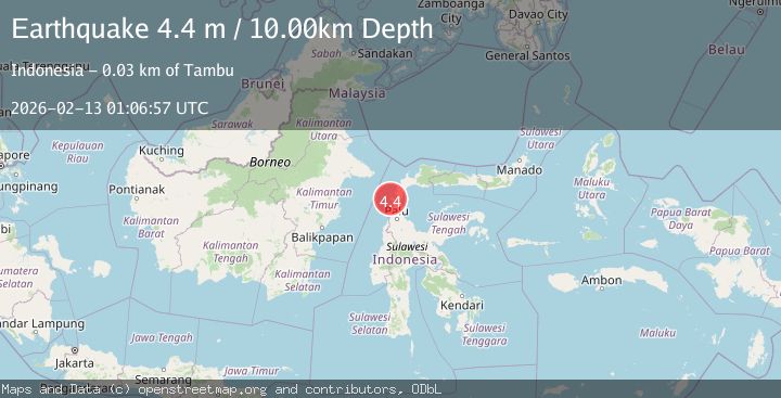
| VYTPrimary | 4.7 | 488 km | 1 week ago |
| BMKG | 4.4 | 10 km | 1 week ago |
Earthquake Details
AutomaticEvent IDvyt_bwozk3y88fv5
Tsunami PotentialNo
Magnitude Typeearthquake
Nearest Places
- Desa Peningka0.7 km
- Peningka1.8 km
- Bulu Sibeine1.8 km
- Bulu Sialalon1.8 km
- Bulu Toriansam2.0 km
Comments
Join the discussion about this event.
Latest Earthquakes
2.5Mag
Java, Indonesia
Time3 minutes ago
Depth16.27 km
SourceBMKG
3.2Mag
Tarapaca, Chile
Time6 minutes ago
Depth111.21 km
SourceVYT (Automatic)
2.0Mag
CENTRAL TURKEY
Time12 minutes ago
Depth3.40 km
SourceKOERI (Automatic)
2.7Mag
Central Alaska
Time14 minutes ago
Depth82.89 km
SourceVYT (Automatic)
1.5Mag
western Texas
Time15 minutes ago
Depth0.49 km
SourceVYT (Automatic)
Nearby Earthquakes
6.1Mag
MINAHASA, SULAWESI, INDONESIA
Time7 years ago
Depth10.00 km
SourceEMSC (Automatic)
3.0Mag
MINAHASA, SULAWESI, INDONESIA
Time5 years ago
Depth10.00 km
SourceDJA (Automatic)
3.0Mag
MINAHASA, SULAWESI, INDONESIA
Time2 years ago
Depth10.00 km
SourceBMKG (Automatic)
3.0Mag
MINAHASA, SULAWESI, INDONESIA
Time1 month ago
Depth13.00 km
SourceBMKG (Automatic)
2.4Mag
Minahassa Peninsula, Sulawesi
Time3 weeks ago
Depth3.37 km
SourceBMKG (Automatic)