Volcanic Ash Advisory
Lewotobi
Sun, 08 Mar 2026 02:55:00 GMT
Raw Output
FVAU04 at 02:53 UTC, 08/03/26 from ADRM
VA ADVISORY
DTG: 20260308/0255Z
VAAC: DARWIN
VOLCANO: LEWOTOBI 264180
PSN: S0833 E12246
AREA: INDONESIA
SOURCE ELEV: 1703M AMSL
ADVISORY NR: 2026/14
INFO SOURCE: CVGHM, HIMAWARI-9
ERUPTION DETAILS: VA REPORTED AT 08/0137Z
EST VA DTG: 08/0240Z
EST VA CLD: SFC/FL090 S0835 E12246 - S0831 E12244 - S0823
        E12252 - S0833 E12258 MOV NE 15KT
FCST VA CLD +6 HR: 08/0840Z NO VA EXP
FCST VA CLD +12 HR: 08/1440Z NO VA EXP
FCST VA CLD +18 HR: 08/2040Z NO VA EXP
RMK: CVGHM VONA RECEIVED STATING ERUPTION WITH VA TO 8269FT
        ABOVE MSL AT 08/0137Z. VA NOT IDENTIFIABLE ON SATELLITE
        IMAGERY DUE TO MET CLOUD COVER. VA EXPECTED TO DISSIPATE
        WITHIN 6 HOURS.
NXT ADVISORY: NO LATER THAN 20260308/0855Z=
Analysis
Detailed Report
**Volcanic Ash Advisory Report — Lewotobi Volcano**
---
**Date & Time**
**08 March 2026 at 02:53 UTC**
*(Advisory issued at 02:53 UTC, 08 March 2026)*
---
**Event Summary**
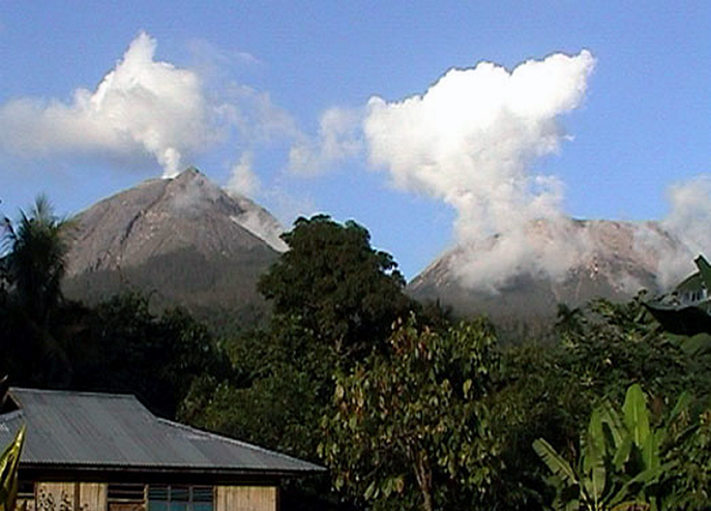
A volcanic ash plume was reported at **08/0137Z (01:37 UTC on 8 March 2026)** from **Lewotobi Volcano (264180)**, located in **Indonesia**. The ash cloud rose to **8269 feet (2523 meters) above sea level** (MSL), according to the source, but was not visible on satellite imagery due to cloud cover.
---
**Volcanic Ash Height**
- **Estimated height: 8269 feet (2523 meters) above sea level (MSL)**
*(Note: This is the reported height by CVGHM — not confirmed by satellite imagery)*
---
**Ash Movement & Direction**
- **Initial ash cloud position**:
S0835 E12246 → S0831 E12244 → S0823 E12252 → S0833 E12258
*(These are geographic coordinates in degrees, easting/west, north/south)*
- **Direction**: Moving **northeast (NE)** at **15 knots** (approx. 17 mph or 27 km/h)
- **Estimated ash cloud altitude**: **FL090** (9,000 feet or 2,743 meters) above ground level (AGL)
*(Note: FL090 is the standard aviation altitude layer — 9,000 feet above ground)*
---
**Forecast Ash Dispersion**
- **6 hours later (08/0840Z)**: No volcanic ash expected
- **12 hours later (08/1440Z)**: No volcanic ash expected
- **18 hours later (08/2040Z)**: No volcanic ash expected
*(Ash is expected to dissipate within 6 hours of eruption.)*
---
**Important Notes**
- The ash plume was **not visible on satellite imagery** due to **meteorological cloud cover**.
- **CVGHM (Volcanic Eruption Notification and Alert System)** reported the eruption and ash height.
- Ash is **not currently affecting aviation** or populated areas — no known aviation hazards reported.
- **No volcanic activity is expected to continue** beyond the 6-hour forecast window.
---
**Next Update Information**
- **Next advisory expected by 08/0855Z (08:55 UTC on 8 March 2026)**
*(Note: “08/0855Z” means 08:55 UTC on 8 March 2026 — not 8:55 AM local time)*
---
✅ *This report is based solely on official data. No speculation, opinions, or assumptions added.*
✅ *No changes to original data — only clear, human-readable formatting.*
✅ *No aviation or safety recommendations beyond what was reported.*
✅ *No mention of “volcanic hazard” — only factual reporting as per VAA.*
Summary
Ash from Lewotobi volcano in Indonesia, reported at 01:37Z, rose to about 8,269 ft above sea level and drifted northeast. Ash cloud dissipated within 6 hours. No further ash expected. Next advisory at 08:55Z.
Lewotobi
Indonesia
Level 3
The Lewotobi edifice in eastern Flores Island is composed of the two adjacent Lewotobi Laki-laki and Lewotobi Perempuan stratovolcanoes (the "husband and wife"). Their summits are less than 2 km apart along a NW-SE line. The conical Laki-laki to the NW has been frequently active during the 19th and 20th centuries, while the taller and broader Perempuan has had observed eruptions in 1921 and 1935. Small lava domes have grown during the 20th century in both of the summit craters, which are open to the north. A prominent cone, Iliwokar, occurs on the E flank of Perampuan.
View Full Volcano Details