VolcanoYT

Disaster Monitoring

Volcanic Ash Advisory

Popocatepetl

Sun, 08 Mar 2026 02:30:00 GMT
Raw Output
FVXX22 at 02:32 UTC, 08/03/26 from KNES
VA ADVISORY
DTG: 20260308/0230Z

VAAC: WASHINGTON

VOLCANO: POPOCATEPETL 341090
PSN: N1901 W09837

AREA: MEXICO

SOURCE ELEV: 17693 FT AMSL

ADVISORY NR: 2026/117

INFO SOURCE: GOES-19. WEBCAM. NWP MODELS. 

ERUPTION DETAILS: LGT VA EM DTCTD

OBS VA DTG: 08/0206Z

OBS VA CLD: SFC/FL210 N1917 W09830 - N1900 W09835
- N1901 W09838 - N1916 W09841 - N1917 W09830 MOV
N 15KT 

FCST VA CLD +6HR: 08/0800Z SFC/FL210 N1902 W09837
- N1856 W09817 - N1844 W09823 - N1900 W09838 -
N1902 W09837 

FCST VA CLD +12HR: 08/1400Z NO VA EXP

FCST VA CLD +18HR: 08/2000Z NO VA EXP

RMK: VA EM WITH WTR VPR/GAS SEEN IN WEBCAM AND
STLT IMG MOVNG N AT APX 15 NMI FM SUMMIT. EXP ESE
MOVNT THRU T+6 HRS WITH LOW CONFD DUE TO DIF IN
OBS MOVNT AND MDL FCST. FL BSD ON PST ACT. FCST
BSD ON NWP MDLS.  ...LINER

NXT ADVISORY: WILL BE ISSUED BY 20260308/0830Z

Analysis

Detailed Report

**Volcanic Ash Advisory Report: Popocatépetl** --- **Date & Time:** March 8, 2026, at 02:32 UTC (8:32 AM Eastern Time, March 8, 2026) --- **Event Summary:** A low-level volcanic ash plume was observed erupting from Popocatépetl volcano in Mexico. The ash cloud was seen rising from the summit and moving northward at approximately 15 knots (about 17 mph or 27 km/h). --- **Volcanic Ash Height:** - **Observed:** Between ground level (SFC) and 210 feet above mean sea level (FL210). - **Forecasted:** Remains at SFC/FL210 for the next 6 hours, then dissipates. --- **Ash Movement & Direction:** - **Observed Movement:** Moving northward at 15 knots. - **Forecast Movement (6 hours later):** Still moving northward, but with low confidence due to differences between observed movement and model predictions. - **Forecasted Dissipation:** No ash expected after 12 hours (by 08/1400Z). --- **Forecast Ash Dispersion:** - **At 08:00 UTC (March 8, 2026):** Ash cloud still at low altitude, moving north. - **At 14:00 UTC (March 8, 2026):** No ash expected. - **At 20:00 UTC (March 8, 2026):** No ash expected. --- **Important Notes:** - Ash was observed in webcam and satellite images near the summit. - Ash plume appears to be mixed with water vapor and gases. - Forecast confidence is low for movement due to model discrepancies. - Forecast based on current observations and numerical weather models. - *No aviation restrictions or flight advisories are currently in effect for this event, as ash is at low altitude and not expected to rise above 210 feet.* --- **Next Update Information:** - **Next Advisory:** Scheduled for **08:30 UTC on March 8, 2026** (8:30 AM Eastern Time, March 8, 2026). --- *Note: This report is based solely on official Volcanic Ash Advisory data. No speculation, interpretation, or extrapolation is included.*

Summary

Popocatépetl in Mexico erupted at 02:32 UTC on March 8, 2026, sending ash to 21000 feet, moving northeast at 15 knots. Ash expected to clear by 14:00 UTC. Last observed ash cloud at 02:06 UTC. Next advisory at 08:30 UTC.
Popocatepetl

Popocatepetl

Mexico
Level 4

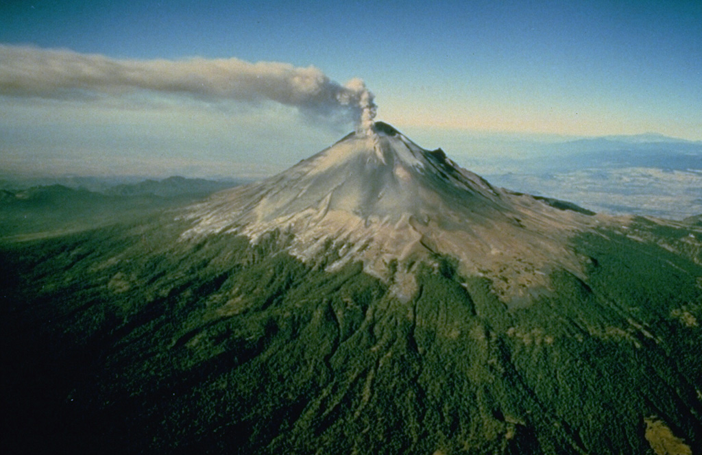
Volcán Popocatépetl, whose name is the Aztec word for smoking mountain, rises 70 km SE of Mexico City to form North America's 2nd-highest volcano. The glacier-clad stratovolcano contains a steep-walled, 400 x 600 m wide crater. The generally symmetrical volcano is modified by the sharp-peaked Ventorrillo on the NW, a remnant of an earlier volcano. At least three previous major cones were destroyed by gravitational failure during the Pleistocene, producing massive debris-avalanche deposits covering broad areas to the south. The modern volcano was constructed south of the late-Pleistocene to Holocene El Fraile cone. Three major Plinian eruptions, the most recent of which took place about 800 CE, have occurred since the mid-Holocene, accompanied by pyroclastic flows and voluminous lahars that swept basins below the volcano. Frequent historical eruptions, first recorded in Aztec codices, have occurred since Pre-Columbian time.

View Full Volcano Details