Earthquake Northern Sumatra, Indonesia
Wed, 07 Jan 2026 09:36:47 GMT
Time2 days ago
Location
3.2141, 96.3312
Depth
3.8 KM
Event Summary
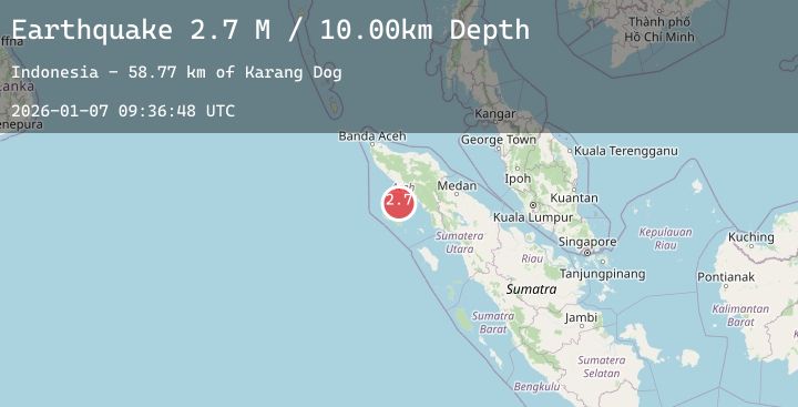
A 2.5 magnitude earthquake struck on Northern Sumatra, Indonesia, at Wed, 07 Jan 2026 09:36:47 GMT. Depth: 3.828832km. Reviewed by BMKG seismologists, this minor quake occurred at a magnitude type of M.
Magnitude
2.5
M
Source
BMKG
Intensity
-
Agency Reports
1 Sources| Source | Magnitude | Depth | Time |
|---|---|---|---|
| BMKGPrimary | 2.5 | 4 km | 2 days ago |
Earthquake Details
AutomaticEvent IDbmg2026alsb
Tsunami PotentialNo
Magnitude TypeM
Nearest Places
- Karang Dog57.0 km
- Ujung Marademan57.6 km
- Ujung Siango57.7 km
- Pulau Tinggi57.9 km
- Lajambaung58.4 km
Comments
Join the discussion about this event.
Latest Earthquakes
3.2Mag
Seram, Indonesia
Time2 days ago
Depth21.98 km
SourceBMKG (Automatic)
2.6Mag
ANTOFAGASTA, CHILE
Time2 days ago
Depth108.80 km
SourceCSN (Automatic)
2.2Mag
3 km WNW of Tanaina, Alaska
Time2 days ago
Depth33.70 km
SourceUSGS (Automatic)
1.6Mag
33 km WSW of Ackerly, Texas
Time2 days ago
Depth4.52 km
SourceUSGS (Automatic)
2.2Mag
FRANCE
Time2 days ago
Depth5.00 km
SourceReNaSS (Automatic)
Nearby Earthquakes
No significant earthquakes nearby recently.