Earthquake Flores Region, Indonesia
Fri, 09 Jan 2026 21:23:28 GMT
Time2 days ago
Location
-8.6551, 123.4486
Depth
92.1 KM
Event Summary
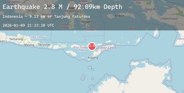
A 2.2 magnitude earthquake struck on Flores Region, Indonesia, at Fri, 09 Jan 2026 21:23:28 GMT. Depth: 92.093224km. Reviewed by BMKG seismologists, this minor quake occurred at a magnitude type of M.
Magnitude
2.2
M
Source
BMKG
Intensity
-
Agency Reports
1 Sources| Source | Magnitude | Depth | Time |
|---|---|---|---|
| BMKGPrimary | 2.2 | 92 km | 2 days ago |
Earthquake Details
AutomaticEvent IDbmg2026aqgj
Tsunami PotentialNo
Magnitude TypeM
Nearest Places
- Tanjung Fatufoko9.1 km
- Tanjung Sarabia9.2 km
- Tanjung Blore9.3 km
- Wai Bukabare9.3 km
- Lamalera9.3 km
Comments
Join the discussion about this event.
Latest Earthquakes
0.7Mag
10 km WNW of The Geysers, CA
Time2 days ago
Depth2.57 km
SourceUSGS (Automatic)
3.5Mag
Ceram Sea
Time2 days ago
Depth10.00 km
SourceBMKG (Automatic)
2.2Mag
Sumbawa Region, Indonesia
Time2 days ago
Depth20.20 km
SourceBMKG (Automatic)
3.1Mag
Banda Sea
Time2 days ago
Depth180.20 km
SourceBMKG (Automatic)
2.8Mag
Sunda Strait, Indonesia
Time2 days ago
Depth10.05 km
SourceBMKG (Automatic)