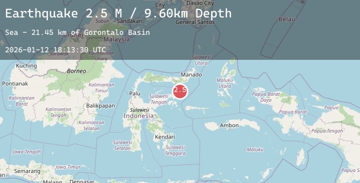
Earthquake Minahassa Peninsula, Sulawesi
Mon, 12 Jan 2026 18:13:31 GMT
Time8 hours ago
Location
-0.3518, 123.8442
Depth
23.0 KM
Event Summary
A 2.6 magnitude earthquake struck on Minahassa Peninsula, Sulawesi, at Mon, 12 Jan 2026 18:13:31 GMT. Depth: 23.049191km. Reviewed by BMKG seismologists, this minor quake occurred at a magnitude type of M.
Magnitude
2.6
M
Source
BMKG
Intensity
-
Agency Reports
1 Sources| Source | Magnitude | Depth | Time |
|---|---|---|---|
| BMKGPrimary | 2.6 | 23 km | 8 hours ago |
Earthquake Details
AutomaticEvent IDbmg2026avmp
Tsunami PotentialNo
Magnitude TypeM
Nearest Places
- Gorontalo Basin20.7 km
- Tanjung Lonsuit58.8 km
- Tanjung Lonsom59.6 km
- Tanjung Ui59.9 km
- Tanjung Ui60.0 km
Comments
Join the discussion about this event.
Latest Earthquakes
2.0Mag
Banda Sea
Time8 hours ago
Depth6.06 km
SourceBMKG (Automatic)
2.5Mag
SOUTHERN CALIFORNIA
Time8 hours ago
Depth5.80 km
SourceSCSN (Automatic)
2.8Mag
82 km SE of Nikolai, Alaska
Time9 hours ago
Depth5.00 km
SourceUSGS (Automatic)
3.4Mag
COSTA RICA
Time9 hours ago
Depth42.00 km
SourceUNA (Automatic)
3.6Mag
EASTERN TURKEY
Time9 hours ago
Depth7.20 km
SourceAFAD (Automatic)