Earthquake Minahassa Peninsula, Sulawesi
Mon, 12 Jan 2026 08:39:51 GMT
Time15 hours ago
Location
-0.3210, 123.5891
Depth
10.0 KM
Event Summary
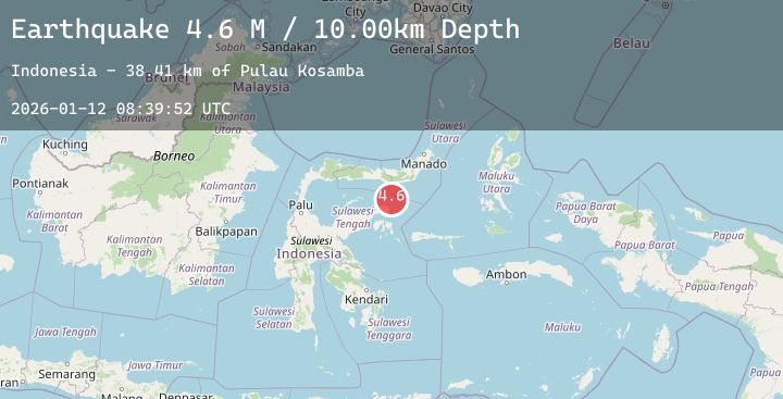
A 4.7 magnitude earthquake struck on Minahassa Peninsula, Sulawesi, at Mon, 12 Jan 2026 08:39:51 GMT. Depth: 10km. Reviewed by BMKG seismologists, this light quake occurred at a magnitude type of M.
Magnitude
4.7
M
Source
BMKG
Intensity
-
Agency Reports
1 Sources| Source | Magnitude | Depth | Time |
|---|---|---|---|
| BMKGPrimary | 4.7 | 10 km | 15 hours ago |
Earthquake Details
AutomaticEvent IDbmg2026autr
Tsunami PotentialNo
Magnitude TypeM
Nearest Places
- Pulau Kosamba41.5 km
- Pulau Toosan41.8 km
- Pulau Ampat41.8 km
- Pulau Daka41.8 km
- Tanjung Lonsom41.8 km
Comments
Join the discussion about this event.
Latest Earthquakes
1.5Mag
53 km W of Happy Valley, Alaska
Time15 hours ago
Depth96.80 km
SourceUSGS (Automatic)
2.7Mag
Java, Indonesia
Time15 hours ago
Depth66.49 km
SourceBMKG (Automatic)
1.5Mag
WESTERN TURKEY
Time15 hours ago
Depth11.50 km
SourceEMSC (Automatic)
0.9Mag
2 km W of Anderson Springs, CA
Time15 hours ago
Depth2.69 km
SourceUSGS (Automatic)
2.3Mag
29 km N of Larsen Bay, Alaska
Time15 hours ago
Depth57.40 km
SourceUSGS (Automatic)