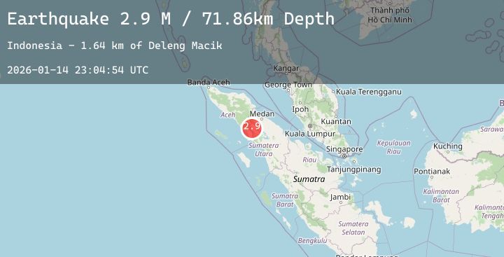
Earthquake Northern Sumatra, Indonesia
Wed, 14 Jan 2026 23:04:54 GMT
Time7 hours ago
Location
3.0095, 97.9846
Depth
71.7 KM
Event Summary
A 2.9 magnitude earthquake struck on Northern Sumatra, Indonesia, at Wed, 14 Jan 2026 23:04:54 GMT. Depth: 71.673927km. Reviewed by BMKG seismologists, this minor quake occurred at a magnitude type of M.
Magnitude
2.9
M
Source
BMKG
Intensity
-
Agency Reports
1 Sources| Source | Magnitude | Depth | Time |
|---|---|---|---|
| BMKGPrimary | 2.9 | 72 km | 7 hours ago |
Earthquake Details
AutomaticEvent IDbmg2026aznf
Tsunami PotentialNo
Magnitude TypeM
Nearest Places
- Desa Alur Subur3.3 km
- Deleng Daholi4.3 km
- Lau Sekilam4.5 km
- Lae Penuban4.8 km
- Desa Mangan Molih5.0 km
Comments
Join the discussion about this event.
Latest Earthquakes
0.7Mag
14 km NNE of Ocotillo Wells, CA
Time7 hours ago
Depth10.23 km
SourceUSGS (Automatic)
2.2Mag
Sulawesi, Indonesia
Time7 hours ago
Depth10.00 km
SourceBMKG (Automatic)
1.6Mag
4 km SE of Home Gardens, CA
Time7 hours ago
Depth1.89 km
SourceUSGS (Automatic)
1.7Mag
10 km W of Ninilchik, Alaska
Time7 hours ago
Depth67.00 km
SourceUSGS (Automatic)
3.1Mag
ALASKA PENINSULA
Time7 hours ago
Depth52.70 km
SourceAK (Automatic)
Nearby Earthquakes
No significant earthquakes nearby recently.