Earthquake Minahassa Peninsula, Sulawesi
Sat, 17 Jan 2026 01:55:37 GMT
Time2 hours ago
Location
0.5095, 121.9603
Depth
129.3 KM
Event Summary
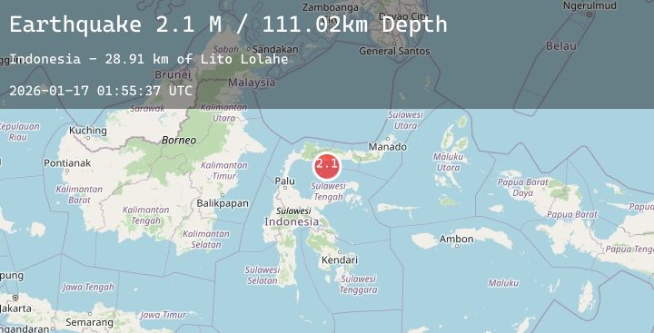
A 2.4 magnitude earthquake struck on Minahassa Peninsula, Sulawesi, at Sat, 17 Jan 2026 01:55:37 GMT. Depth: 129.291122km. Reviewed by BMKG seismologists, this minor quake occurred at a magnitude type of M.
Magnitude
2.4
M
Source
BMKG
Intensity
-
Agency Reports
1 Sources| Source | Magnitude | Depth | Time |
|---|---|---|---|
| BMKGPrimary | 2.4 | 129 km | 2 hours ago |
Earthquake Details
AutomaticEvent IDbmg2026bdjw
Tsunami PotentialNo
Magnitude TypeM
Nearest Places
- Desa Taluduyunu1.2 km
- Batudaa1.4 km
- Wibudu1.5 km
- Desa Bulangita2.1 km
- Desa Taluduyunu Utara2.2 km
Comments
Join the discussion about this event.
Latest Earthquakes
1.9Mag
6 km SW of Volcano, Hawaii
Time1 hour ago
Depth0.14 km
SourceUSGS (Automatic)
1.8Mag
61 km NNW of Rachel, Nevada
Time1 hour ago
Depth0.01 km
SourceUSGS (Automatic)
0.8Mag
83 km NW of Karluk, Alaska
Time1 hour ago
Depth0.80 km
SourceUSGS (Automatic)
0.7Mag
15 km SE of Anza, CA
Time2 hours ago
Depth9.75 km
SourceUSGS (Automatic)
1.3Mag
WESTERN TURKEY
Time2 hours ago
Depth6.90 km
SourceAFAD (Automatic)