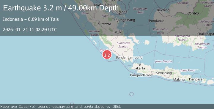
Earthquake Southern Sumatra, Indonesia
Wed, 21 Jan 2026 11:02:20 GMT
Time6 days ago
Location
-4.6872, 102.0163
Depth
48.7 KM
Event Summary
A 3.2 magnitude earthquake struck on Southern Sumatra, Indonesia, at Wed, 21 Jan 2026 11:02:20 GMT. Depth: 48.74947km. Reviewed by BMKG seismologists, this minor quake occurred at a magnitude type of M.
Magnitude
3.2
M
Source
BMKG
Intensity
-
Agency Reports
1 Sources| Source | Magnitude | Depth | Time |
|---|---|---|---|
| BMKGPrimary | 3.2 | 49 km | 6 days ago |
Earthquake Details
AutomaticEvent IDbmg2026bljx
Tsunami PotentialNo
Magnitude TypeM
Nearest Places
- Tanjung Lakoaha67.9 km
- Lakoaha68.0 km
- Sungai Hubaje68.4 km
- Kampungbaru70.2 km
- Batang Mea70.6 km
Comments
Join the discussion about this event.
Latest Earthquakes
2.0Mag
WESTERN TURKEY
Time19 hours ago
Depth7.60 km
SourceKOERI (Automatic)
4.4Mag
Sulawesi, Indonesia
Time19 hours ago
Depth5.00 km
SourceBMKG (Automatic)
1.8Mag
PYRENEES
Time20 hours ago
Depth1.40 km
SourceIGN (Automatic)
2.6Mag
Minahassa Peninsula, Sulawesi
Time20 hours ago
Depth118.00 km
SourceBMKG (Automatic)
2.8Mag
South of Bali, Indonesia
Time20 hours ago
Depth10.00 km
SourceBMKG (Automatic)
Nearby Earthquakes
3.2Mag
Southern Sumatra, Indonesia
Time3 days ago
Depth10.00 km
SourceBMKG (Automatic)
2.6Mag
Southern Sumatra, Indonesia
Time1 day ago
Depth25.66 km
SourceBMKG (Automatic)
2.9Mag
Southwest of Sumatra, Indonesia
Time4 days ago
Depth94.33 km
SourceBMKG (Automatic)
3.6Mag
Southern Sumatra, Indonesia
Time3 days ago
Depth11.08 km
SourceBMKG (Automatic)
3.9Mag
Southern Sumatra, Indonesia
Time6 days ago
Depth10.00 km
SourceBMKG (Automatic)