Earthquake West Papua, Indonesia
Wed, 21 Jan 2026 18:25:14 GMT
Time5 days ago
Location
-3.3348, 140.6267
Depth
41.6 KM
Event Summary
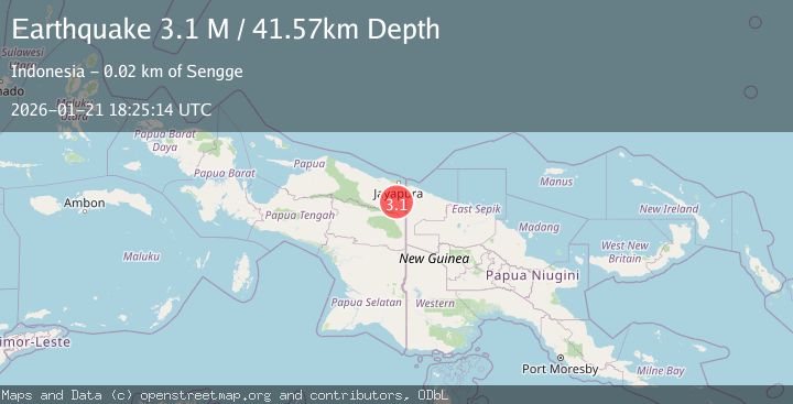
A 3.1 magnitude earthquake struck on West Papua, Indonesia, at Wed, 21 Jan 2026 18:25:14 GMT. Depth: 41.574108km. Reviewed by BMKG seismologists, this minor quake occurred at a magnitude type of M.
Magnitude
3.1
M
Source
BMKG
Intensity
-
Agency Reports
1 Sources| Source | Magnitude | Depth | Time |
|---|---|---|---|
| BMKGPrimary | 3.1 | 42 km | 5 days ago |
Earthquake Details
AutomaticEvent IDbmg2026blyn
Tsunami PotentialNo
Magnitude TypeM
Nearest Places
- Kabupaten Keerom6.3 km
- Kampung Senggi7.0 km
- Distrik Senggi10.5 km
- Kampung Waley16.6 km
- Molof17.3 km
Comments
Join the discussion about this event.
Latest Earthquakes
2.0Mag
WESTERN TURKEY
Time13 hours ago
Depth7.60 km
SourceKOERI (Automatic)
4.4Mag
Sulawesi, Indonesia
Time13 hours ago
Depth5.00 km
SourceBMKG (Automatic)
1.8Mag
PYRENEES
Time13 hours ago
Depth1.40 km
SourceIGN (Automatic)
2.6Mag
Minahassa Peninsula, Sulawesi
Time13 hours ago
Depth118.00 km
SourceBMKG (Automatic)
2.8Mag
South of Bali, Indonesia
Time13 hours ago
Depth10.00 km
SourceBMKG (Automatic)
Nearby Earthquakes
2.5Mag
West Papua, Indonesia
Time4 days ago
Depth10.00 km
SourceBMKG (Automatic)
2.6Mag
West Papua, Indonesia
Time2 days ago
Depth22.39 km
SourceBMKG (Automatic)
2.3Mag
Near North Coast of West Papua
Time4 days ago
Depth10.00 km
SourceBMKG (Automatic)
2.8Mag
West Papua, Indonesia
Time3 days ago
Depth10.00 km
SourceBMKG (Automatic)
2.4Mag
Near North Coast of West Papua
Time2 days ago
Depth10.00 km
SourceBMKG (Automatic)