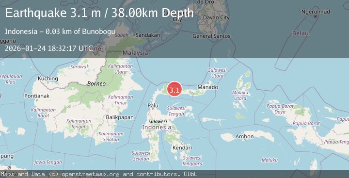
Earthquake Minahassa Peninsula, Sulawesi
Sat, 24 Jan 2026 18:32:17 GMT
Time2 days ago
Location
0.9445, 121.8517
Depth
38.1 KM
Event Summary
A 3.1 magnitude earthquake struck on Minahassa Peninsula, Sulawesi, at Sat, 24 Jan 2026 18:32:17 GMT. Depth: 38.148212km. Reviewed by BMKG seismologists, this minor quake occurred at a magnitude type of M.
Magnitude
3.1
M
Source
BMKG
Intensity
-
Agency Reports
1 Sources| Source | Magnitude | Depth | Time |
|---|---|---|---|
| BMKGPrimary | 3.1 | 38 km | 2 days ago |
Earthquake Details
AutomaticEvent IDbmg2026brlg
Tsunami PotentialNo
Magnitude TypeM
Nearest Places
- Dutula Himbuloa2.9 km
- Dutula Buhu Daa3.7 km
- Dutula Buhu Kiki3.7 km
- Huidu Timbulon4.0 km
- Mbukid Tabodok5.0 km
Comments
Join the discussion about this event.
Latest Earthquakes
4.4Mag
Sulawesi, Indonesia
Time16 hours ago
Depth5.00 km
SourceBMKG (Automatic)
1.8Mag
PYRENEES
Time17 hours ago
Depth1.40 km
SourceIGN (Automatic)
2.6Mag
Minahassa Peninsula, Sulawesi
Time17 hours ago
Depth118.00 km
SourceBMKG (Automatic)
2.8Mag
South of Bali, Indonesia
Time17 hours ago
Depth10.00 km
SourceBMKG (Automatic)
1.7Mag
31 km SE of Denali National Park, Alaska
Time17 hours ago
Depth0.60 km
SourceUSGS (Automatic)
Nearby Earthquakes
2.1Mag
Minahassa Peninsula, Sulawesi
Time2 days ago
Depth99.65 km
SourceBMKG (Automatic)
2.0Mag
Minahassa Peninsula, Sulawesi
Time6 days ago
Depth2.50 km
SourceBMKG (Automatic)
2.4Mag
Minahassa Peninsula, Sulawesi
Time6 days ago
Depth60.37 km
SourceBMKG (Automatic)
2.2Mag
Minahassa Peninsula, Sulawesi
Time5 days ago
Depth76.64 km
SourceBMKG (Automatic)
2.4Mag
Minahassa Peninsula, Sulawesi
Time22 hours ago
Depth10.24 km
SourceBMKG (Automatic)