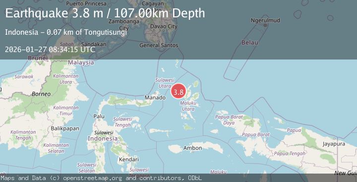
Earthquake Northern Molucca Sea
Tue, 27 Jan 2026 08:34:14 GMT
Time3 hours ago
Location
1.7112, 126.9524
Depth
121.4 KM
Event Summary
A 3.1 magnitude earthquake struck on Northern Molucca Sea, at Tue, 27 Jan 2026 08:34:14 GMT. Depth: 121.374054km. Reviewed by BMKG seismologists, this minor quake occurred at a magnitude type of M.
Magnitude
3.1
M
Source
BMKG
Intensity
-
Agency Reports
1 Sources| Source | Magnitude | Depth | Time |
|---|---|---|---|
| BMKGPrimary | 3.1 | 121 km | 3 hours ago |
Earthquake Details
AutomaticEvent IDbmg2026bweb
Tsunami PotentialNo
Magnitude TypeM
Nearest Places
- Nyi26.1 km
- Nusa Nyaolaka59.3 km
- Nusa Sidanga59.4 km
- Nusa Sosota60.1 km
- Kepulauan Loloda Selatan61.1 km
Comments
Join the discussion about this event.
Latest Earthquakes
1.2Mag
21 km NNE of Indio, CA
Time3 hours ago
Depth5.59 km
SourceUSGS (Automatic)
0.7Mag
22 km NE of Four Mile Road, Alaska
Time3 hours ago
Depth28.90 km
SourceUSGS (Automatic)
4.3Mag
Java, Indonesia
Time3 hours ago
Depth37.35 km
SourceBMKG (Automatic)
2.2Mag
SWITZERLAND
Time3 hours ago
Depth12.20 km
SourceReNaSS (Automatic)
2.6Mag
KARNATAKA, INDIA
Time4 hours ago
Depth5.00 km
SourceNDI (Automatic)
Nearby Earthquakes
3.9Mag
Halmahera, Indonesia
Time6 days ago
Depth10.00 km
SourceBMKG (Automatic)
3.5Mag
Northern Molucca Sea
Time3 days ago
Depth17.49 km
SourceBMKG (Automatic)
2.6Mag
Northern Molucca Sea
Time2 days ago
Depth61.16 km
SourceBMKG (Automatic)
3.2Mag
Halmahera, Indonesia
Time1 day ago
Depth114.35 km
SourceBMKG (Automatic)
4.7Mag
Northern Molucca Sea
Time5 days ago
Depth23.34 km
SourceBMKG (Automatic)