Earthquake Bali Region, Indonesia
Wed, 28 Jan 2026 16:45:36 GMT
Time1 hour ago
Location
-8.6991, 114.8593
Depth
53.0 KM
Event Summary
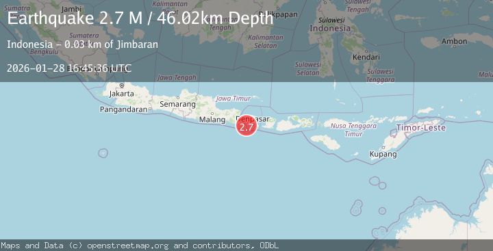
A 2.6 magnitude earthquake struck on Bali Region, Indonesia, at Wed, 28 Jan 2026 16:45:36 GMT. Depth: 53.022388km. Reviewed by BMKG seismologists, this minor quake occurred at a magnitude type of M.
Magnitude
2.6
M
Source
BMKG
Intensity
-
Agency Reports
1 Sources| Source | Magnitude | Depth | Time |
|---|---|---|---|
| BMKGPrimary | 2.6 | 53 km | 1 hour ago |
Earthquake Details
AutomaticEvent IDbmg2026bypt
Tsunami PotentialNo
Magnitude TypeM
Nearest Places
- Tukadyeh Matan22.3 km
- Enjung Pamegalan23.6 km
- Enjung Bulungdaya23.8 km
- Muara Mancingan23.8 km
- Enjung Menalo23.8 km
Comments
Join the discussion about this event.
Latest Earthquakes
2.3Mag
Halmahera, Indonesia
Time1 hour ago
Depth10.09 km
SourceBMKG (Automatic)
3.8Mag
CENTRAL PERU
Time1 hour ago
Depth14.00 km
SourceLIM (Automatic)
2.0Mag
Flores Sea
Time2 hours ago
Depth20.61 km
SourceBMKG (Automatic)
2.1Mag
SOUTHERN CALIFORNIA
Time2 hours ago
Depth5.50 km
SourceSCSN (Automatic)
2.2Mag
SPAIN
Time2 hours ago
Depth0.00 km
SourceIGN (Automatic)
Nearby Earthquakes
2.5Mag
Bali Region, Indonesia
Time1 week ago
Depth90.70 km
SourceBMKG (Automatic)
2.5Mag
Bali Region, Indonesia
Time6 days ago
Depth105.42 km
SourceBMKG (Automatic)
2.4Mag
Bali Region, Indonesia
Time1 day ago
Depth110.29 km
SourceBMKG (Automatic)
2.6Mag
South of Bali, Indonesia
Time2 days ago
Depth158.81 km
SourceBMKG (Automatic)
2.8Mag
South of Bali, Indonesia
Time1 day ago
Depth10.00 km
SourceBMKG (Automatic)