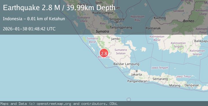
Earthquake Southern Sumatra, Indonesia
Fri, 30 Jan 2026 01:48:41 GMT
Time3 hours ago
Location
-3.4052, 101.8970
Depth
49.9 KM
Event Summary
A 2.7 magnitude earthquake struck on Southern Sumatra, Indonesia, at Fri, 30 Jan 2026 01:48:41 GMT. Depth: 49.888264km. Reviewed by BMKG seismologists, this minor quake occurred at a magnitude type of M.
Magnitude
2.7
M
Source
BMKG
Intensity
-
Agency Reports
1 Sources| Source | Magnitude | Depth | Time |
|---|---|---|---|
| BMKGPrimary | 2.7 | 50 km | 3 hours ago |
Earthquake Details
AutomaticEvent IDbmg2026cbde
Tsunami PotentialNo
Magnitude TypeM
Nearest Places
- Desa Air Simpang0.8 km
- Serangai1.8 km
- Sungai Limas2.0 km
- Talangbaru2.6 km
- Sungai Serenggai2.7 km
Comments
Join the discussion about this event.
Latest Earthquakes
2.3Mag
Southern Sumatra, Indonesia
Time3 hours ago
Depth18.59 km
SourceBMKG (Automatic)
2.6Mag
Seram, Indonesia
Time3 hours ago
Depth10.00 km
SourceBMKG (Automatic)
2.1Mag
EASTERN TURKEY
Time3 hours ago
Depth12.80 km
SourceKOERI (Automatic)
2.3Mag
OKLAHOMA
Time3 hours ago
Depth2.80 km
SourceOK (Automatic)
2.6Mag
Halmahera, Indonesia
Time3 hours ago
Depth121.03 km
SourceBMKG (Automatic)
Nearby Earthquakes
2.6Mag
Southern Sumatra, Indonesia
Time4 days ago
Depth25.66 km
SourceBMKG (Automatic)
3.6Mag
Southern Sumatra, Indonesia
Time2 days ago
Depth72.51 km
SourceBMKG (Automatic)
3.2Mag
Southern Sumatra, Indonesia
Time11 hours ago
Depth23.74 km
SourceBMKG (Automatic)
3.9Mag
Southern Sumatra, Indonesia
Time1 week ago
Depth10.00 km
SourceBMKG (Automatic)
2.7Mag
Southern Sumatra, Indonesia
Time6 days ago
Depth129.75 km
SourceBMKG (Automatic)