Earthquake Southern Sumatra, Indonesia
Fri, 30 Jan 2026 23:01:59 GMT
Time7 hours ago
Location
-2.1010, 100.5498
Depth
11.5 KM
Event Summary
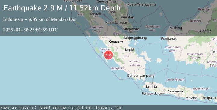
A 2.9 magnitude earthquake struck on Southern Sumatra, Indonesia, at Fri, 30 Jan 2026 23:01:59 GMT. Depth: 11.518255km. Reviewed by BMKG seismologists, this minor quake occurred at a magnitude type of M.
Magnitude
2.9
M
Source
BMKG
Intensity
-
Agency Reports
1 Sources| Source | Magnitude | Depth | Time |
|---|---|---|---|
| BMKGPrimary | 2.9 | 12 km | 7 hours ago |
Earthquake Details
AutomaticEvent IDbmg2026ccte
Tsunami PotentialNo
Magnitude TypeM
Nearest Places
- Pulau Baringin23.7 km
- Pulau Katangkatang24.1 km
- Ujung Indrapura30.0 km
- Air Patah30.1 km
- Air Napuh32.8 km
Comments
Join the discussion about this event.
Latest Earthquakes
2.2Mag
Java, Indonesia
Time7 hours ago
Depth133.89 km
SourceBMKG (Automatic)
3.6Mag
OFFSHORE EL SALVADOR
Time8 hours ago
Depth26.00 km
SourceINET (Automatic)
3.0Mag
MYANMAR
Time8 hours ago
Depth10.00 km
SourceTSB (Automatic)
2.1Mag
36 km W of Karluk, Alaska
Time8 hours ago
Depth64.30 km
SourceUSGS (Automatic)
3.0Mag
ANTOFAGASTA, CHILE
Time8 hours ago
Depth95.90 km
SourceCSN (Automatic)
Nearby Earthquakes
3.5Mag
Southern Sumatra, Indonesia
Time4 days ago
Depth46.40 km
SourceBMKG (Automatic)
2.8Mag
Southern Sumatra, Indonesia
Time1 day ago
Depth29.81 km
SourceBMKG (Automatic)
3.5Mag
Southern Sumatra, Indonesia
Time11 hours ago
Depth20.50 km
SourceBMKG (Automatic)
3.8Mag
Southern Sumatra, Indonesia
Time1 week ago
Depth3.60 km
SourceBMKG (Automatic)
2.5Mag
Southern Sumatra, Indonesia
Time4 days ago
Depth15.39 km
SourceBMKG (Automatic)