Earthquake Papua New Guinea Region
Tue, 03 Feb 2026 19:21:40 GMT
Time2 months ago
Location
-6.2853, 147.5672
Depth
90.7 KM
Event Summary
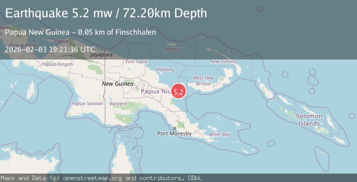
A 5.1 magnitude earthquake struck on Papua New Guinea Region, at Tue, 03 Feb 2026 19:21:40 GMT. Depth: 90.744568km. Reviewed by BMKG seismologists, this moderate quake occurred at a magnitude type of M.
Magnitude
5.1
M
Source
BMKG
Intensity
III
Agency Reports
4 Sources| Source | Magnitude | Depth | Time |
|---|---|---|---|
| BMKGPrimary | 5.1 | 91 km | 2 months ago |
| GFZ | 5.2 | 68 km | 2 months ago |
| EMSC | 5.2 | 75 km | 2 months ago |
| NEIC | 5.2 | 72 km | 2 months ago |
Earthquake Details
AutomaticEvent IDbmg2026cjtx
QualityS
Tsunami PotentialNo
Magnitude TypeM
Last Update2 months ago
Nearest Places
Possibly felt by: 59.6K
- IIIFinschhafen47.1 km1.1K people
- IIILae79.7 km76.3K people
- IIBulolo144.6 km16K people
- IIWau149.9 km14.6K people
- IIKainantu188.1 km8.5K people
- 219.1 km1K people
- 229.8 km27.4K people
- 242.1 km18.5K people
- 271.8 km5.6K people
- 285.4 km28.2K people
- 288.7 km9.4K people
- 288.9 km6.2K people
- 295.8 km18.8K people
- IIhu299.3 km
- IMinj320.7 km
- 328.2 km
- 357.9 km283.7K people
Felt Reports0
Did you feel this earthquake? Report it to help others.
No reports yet
Be the first to report this earthquake!
Latest Earthquakes
Loading...
Nearby Earthquakes
4.9Mag
eastern New Guinea region, Papua New Guinea
Time2 weeks ago
Depth60.30 km
SourceVYT (Automatic)
3.5Mag
eastern New Guinea region, Papua New Guinea
Time3 weeks ago
Depth0.00 km
SourceVYT (Automatic)
4.7Mag
eastern New Guinea region, Papua New Guinea
Time3 weeks ago
Depth186.89 km
SourceVYT (Automatic)
3.8Mag
eastern New Guinea region, Papua New Guinea
Time0 months ago
Depth254.03 km
SourceVYT (Automatic)
3.5Mag
eastern New Guinea region, Papua New Guinea
Time1 month ago
Depth96.07 km
SourceVYT (Automatic)