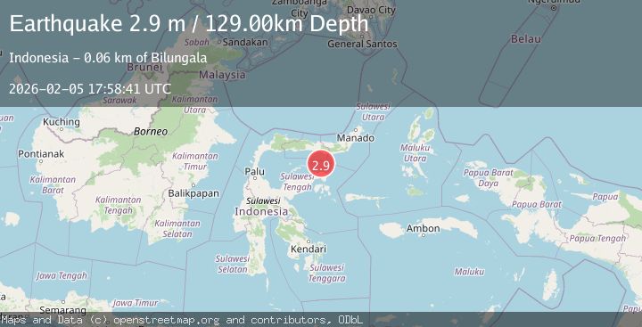
Earthquake Minahassa Peninsula, Sulawesi
Thu, 05 Feb 2026 17:58:41 GMT
Time1 hour ago
Location
-0.1693, 123.1543
Depth
129.0 KM
Event Summary
A 2.9 magnitude earthquake struck on Minahassa Peninsula, Sulawesi, at Thu, 05 Feb 2026 17:58:41 GMT. Depth: 128.997437km. Reviewed by BMKG seismologists, this minor quake occurred at a magnitude type of M.
Magnitude
2.9
M
Source
BMKG
Intensity
-
Agency Reports
1 Sources| Source | Magnitude | Depth | Time |
|---|---|---|---|
| BMKGPrimary | 2.9 | 129 km | 1 hour ago |
Earthquake Details
AutomaticEvent IDbmg2026cnif
Tsunami PotentialNo
Magnitude TypeM
Nearest Places
- Pulau Mantawalu Daka39.0 km
- Pulau Sendiri41.2 km
- Pulau Mantawalu Ise42.6 km
- Padang45.1 km
- Tanjung Awok45.3 km
Comments
Join the discussion about this event.
Latest Earthquakes
0.9Mag
6 km NW of Parkfield, CA
Time5 minutes ago
Depth4.97 km
SourceUSGS (Automatic)
0.3Mag
8 km NW of The Geysers, CA
Time11 minutes ago
Depth1.50 km
SourceUSGS (Automatic)
2.7Mag
SAN JUAN, ARGENTINA
Time11 minutes ago
Depth79.00 km
SourceNSNA (Automatic)
1.9Mag
47 km NNE of Petersville, Alaska
Time19 minutes ago
Depth88.00 km
SourceUSGS (Automatic)
1.5Mag
10 km NNE of Odessa, Texas
Time26 minutes ago
Depth4.60 km
SourceUSGS (Automatic)
Nearby Earthquakes
2.5Mag
SULAWESI, INDONESIA
Time4 days ago
Depth101.00 km
SourceBMKG (Automatic)
3.0Mag
Minahassa Peninsula, Sulawesi
Time21 hours ago
Depth113.48 km
SourceBMKG (Automatic)
2.6Mag
Minahassa Peninsula, Sulawesi
Time1 week ago
Depth132.63 km
SourceBMKG (Automatic)
2.8Mag
Minahassa Peninsula, Sulawesi
Time1 week ago
Depth97.44 km
SourceBMKG (Automatic)
2.9Mag
Minahassa Peninsula, Sulawesi
Time3 days ago
Depth135.60 km
SourceBMKG (Automatic)