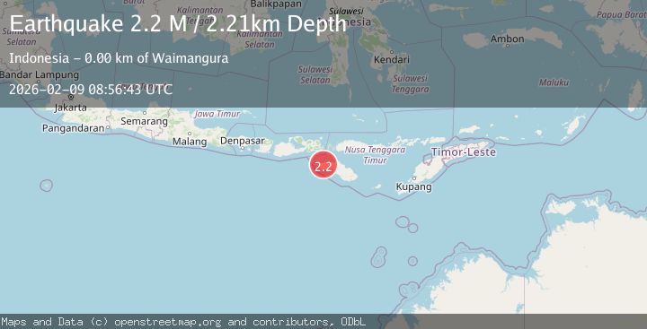
Earthquake Sumba Region, Indonesia
Mon, 09 Feb 2026 08:56:43 GMT
Time1 hour ago
Location
-9.4845, 119.2055
Depth
2.2 KM
Event Summary
A 2.2 magnitude earthquake struck on Sumba Region, Indonesia, at Mon, 09 Feb 2026 08:56:43 GMT. Depth: 2.206704km. Reviewed by BMKG seismologists, this minor quake occurred at a magnitude type of M.
Magnitude
2.2
M
Source
BMKG
Intensity
-
Agency Reports
1 Sources| Source | Magnitude | Depth | Time |
|---|---|---|---|
| BMKGPrimary | 2.2 | 2 km | 1 hour ago |
Earthquake Details
AutomaticEvent IDbmg2026ctyi
Tsunami PotentialNo
Magnitude TypeM
Nearest Places
- Desa Reda Pada0.2 km
- Letena Klakibela0.6 km
- Puuede0.9 km
- Puumao1.1 km
- Wanomadeta1.2 km
Comments
Join the discussion about this event.
Latest Earthquakes
1.4Mag
23 km ENE of San Lucas, CA
Time1 hour ago
Depth7.44 km
SourceUSGS (Automatic)
1.1Mag
11 km ENE of Ridgecrest, CA
Time1 hour ago
Depth1.44 km
SourceUSGS (Automatic)
2.9Mag
WESTERN TURKEY
Time2 hours ago
Depth6.90 km
SourceKOERI (Automatic)
0.8Mag
12 km SSE of Big Bear City, CA
Time2 hours ago
Depth9.97 km
SourceUSGS (Automatic)
2.4Mag
SPAIN
Time2 hours ago
Depth1.00 km
SourceIGN (Automatic)
Nearby Earthquakes
2.4Mag
Sumba Region, Indonesia
Time1 week ago
Depth66.34 km
SourceBMKG (Automatic)
2.3Mag
Sumba Region, Indonesia
Time1 week ago
Depth63.48 km
SourceBMKG (Automatic)
2.3Mag
Sumba Region, Indonesia
Time1 week ago
Depth41.02 km
SourceBMKG (Automatic)
2.3Mag
Sumba Region, Indonesia
Time1 week ago
Depth8.14 km
SourceBMKG (Automatic)
2.4Mag
Sumba Region, Indonesia
Time1 week ago
Depth53.59 km
SourceBMKG (Automatic)