Earthquake Seram, Indonesia
Mon, 09 Feb 2026 17:41:36 GMT
Time1 hour ago
Location
-2.9150, 130.0379
Depth
11.0 KM
Event Summary
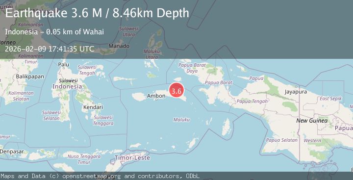
A 3.1 magnitude earthquake struck on Seram, Indonesia, at Mon, 09 Feb 2026 17:41:36 GMT. Depth: 10.975979km. Reviewed by BMKG seismologists, this minor quake occurred at a magnitude type of M.
Magnitude
3.1
M
Source
BMKG
Intensity
-
Agency Reports
1 Sources| Source | Magnitude | Depth | Time |
|---|---|---|---|
| BMKGPrimary | 3.1 | 11 km | 1 hour ago |
Earthquake Details
AutomaticEvent IDbmg2026cupq
Tsunami PotentialNo
Magnitude TypeM
Nearest Places
- Tanjung Boti7.9 km
- Ake Ternate9.1 km
- Wae Boti9.7 km
- Wae Lofin10.2 km
- Boti10.3 km
Comments
Join the discussion about this event.
Latest Earthquakes
0.7Mag
6 km NW of The Geysers, CA
Time1 hour ago
Depth3.21 km
SourceUSGS (Automatic)
2.7Mag
Timor Region
Time1 hour ago
Depth95.97 km
SourceBMKG (Automatic)
1.2Mag
EASTERN TURKEY
Time1 hour ago
Depth6.90 km
SourceAFAD (Automatic)
3.0Mag
COOK STRAIT, NEW ZEALAND
Time2 hours ago
Depth38.30 km
SourceGNS (Automatic)
1.2Mag
20 km NNW of Amboy, Washington
Time2 hours ago
Depth12.18 km
SourceUSGS
Nearby Earthquakes
3.3Mag
Seram, Indonesia
Time1 week ago
Depth10.00 km
SourceBMKG (Automatic)
3.0Mag
Seram, Indonesia
Time1 day ago
Depth15.64 km
SourceBMKG (Automatic)
2.6Mag
Seram, Indonesia
Time2 weeks ago
Depth9.93 km
SourceBMKG (Automatic)
2.4Mag
Seram, Indonesia
Time1 week ago
Depth8.87 km
SourceBMKG (Automatic)
2.6Mag
Seram, Indonesia
Time3 days ago
Depth10.00 km
SourceBMKG (Automatic)