Earthquake Timor Region
Tue, 10 Feb 2026 16:23:46 GMT
Time1 week ago
Location
-10.0195, 124.5127
Depth
5.4 KM
Event Summary
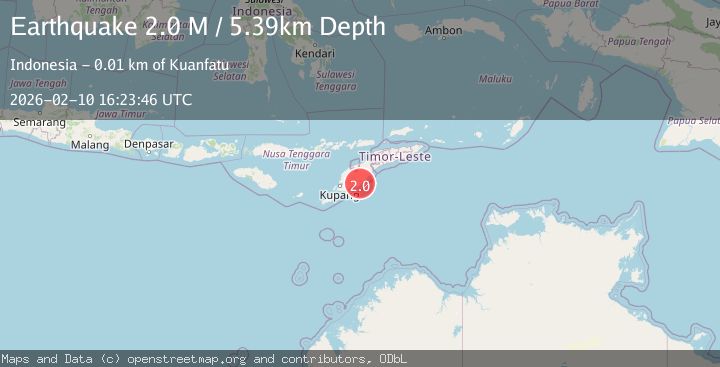
A 2.0 magnitude earthquake struck on Timor Region, at Tue, 10 Feb 2026 16:23:46 GMT. Depth: 5.393169km. Reviewed by BMKG seismologists, this minor quake occurred at a magnitude type of M.
Magnitude
2.0
M
Source
BMKG
Intensity
-
Agency Reports
1 Sources| Source | Magnitude | Depth | Time |
|---|---|---|---|
| BMKGPrimary | 2.0 | 5 km | 1 week ago |
Earthquake Details
ManualEvent IDbmg2026cwio
Tsunami PotentialNo
Magnitude TypeM
Nearest Places
- Desa Pene Selatan1.0 km
- Kolbano2.0 km
- Desa Se’i2.1 km
- Mopoeno2.1 km
- Desa Kolbano2.1 km
Comments
Join the discussion about this event.
Latest Earthquakes
3.8Mag
Andreanof Islands, Aleutian Islands, Alaska
Time22 hours ago
Depth15.50 km
SourceVYT (Automatic)
1.7Mag
40 km NW of Toyah, Texas
Time22 hours ago
Depth4.25 km
SourceUSGS (Automatic)
1.3Mag
SWITZERLAND
Time22 hours ago
Depth7.60 km
SourceETHZ (Automatic)
2.7Mag
Andreanof Islands, Aleutian Islands, Alaska
Time23 hours ago
Depth29.17 km
SourceVYT (Automatic)
1.6Mag
44 km NW of Toyah, Texas
Time23 hours ago
Depth0.00 km
SourceUSGS (Automatic)
Nearby Earthquakes
3.0Mag
TIMOR REGION, INDONESIA
Time3 years ago
Depth28.00 km
SourceDJA (Automatic)
3.0Mag
TIMOR REGION, INDONESIA
Time2 years ago
Depth10.00 km
SourceBMKG (Automatic)
2.5Mag
TIMOR REGION
Time1 month ago
Depth180.00 km
SourceBMKG (Automatic)
2.2Mag
Timor Region
Time2 days ago
Depth17.95 km
SourceBMKG
5.6Mag
TIMOR REGION, INDONESIA
Time20 years ago
Depth60.00 km
SourceEMSC (Automatic)