Earthquake Talaud Islands, Indonesia
Tue, 10 Feb 2026 23:12:36 GMT
Time1 week ago
Location
4.8161, 125.2248
Depth
33.1 KM
Event Summary
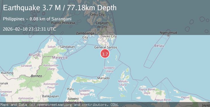
A 4.3 magnitude earthquake struck on Talaud Islands, Indonesia, at Tue, 10 Feb 2026 23:12:36 GMT. Depth: 33.083111km. Reviewed by BMKG seismologists, this light quake occurred at a magnitude type of M.
Magnitude
4.3
M
Source
BMKG
Intensity
-
Agency Reports
1 Sources| Source | Magnitude | Depth | Time |
|---|---|---|---|
| BMKGPrimary | 4.3 | 33 km | 1 week ago |
Earthquake Details
ManualEvent IDbmg2026cwwb
Tsunami PotentialNo
Magnitude TypeM
Nearest Places
- Pulau Kawio28.2 km
- Desa Kawio28.3 km
- Pulau Dakole28.5 km
- Pulau Kemboleng29.3 km
- Desa Marore30.0 km
Comments
Join the discussion about this event.
Latest Earthquakes
2.4Mag
West Papua Region, Indonesia
Time1 hour ago
Depth10.00 km
SourceBMKG
3.3Mag
Talaud Islands, Indonesia
Time1 hour ago
Depth10.00 km
SourceBMKG
1.1Mag
4 km NW of The Geysers, CA
Time1 hour ago
Depth3.39 km
SourceUSGS (Automatic)
1.0Mag
33 km WSW of Ackerly, Texas
Time1 hour ago
Depth4.44 km
SourceUSGS (Automatic)
2.8Mag
Antofagasta, Chile
Time1 hour ago
Depth0.00 km
SourceVYT (Automatic)
Nearby Earthquakes
3.0Mag
KEPULAUAN SANGIHE, INDONESIA
Time3 years ago
Depth211.00 km
SourcePIVS (Automatic)
4.5Mag
Talaud Islands, Indonesia
Time2 weeks ago
Depth10.00 km
SourceBMKG (Automatic)
5.0Mag
KEPULAUAN SANGIHE, INDONESIA
Time1 year ago
Depth10.00 km
SourceEMSC (Automatic)
5.0Mag
KEPULAUAN SANGIHE, INDONESIA
Time13 years ago
Depth40.00 km
SourceEMSC (Automatic)
5.1Mag
KEPULAUAN SANGIHE, INDONESIA
Time6 years ago
Depth60.00 km
SourceEMSC (Automatic)