Earthquake South of Sumbawa, Indonesia
Thu, 12 Feb 2026 21:52:00 GMT
Time5 days ago
Location
-11.1005, 117.6586
Depth
34.5 KM
Event Summary
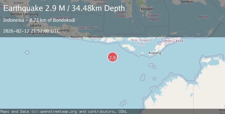
A 2.9 magnitude earthquake struck on South of Sumbawa, Indonesia, at Thu, 12 Feb 2026 21:52:00 GMT. Depth: 34.481297km. Reviewed by BMKG seismologists, this minor quake occurred at a magnitude type of M.
Magnitude
2.9
M
Source
BMKG
Intensity
-
Agency Reports
1 Sources| Source | Magnitude | Depth | Time |
|---|---|---|---|
| BMKGPrimary | 2.9 | 34 km | 5 days ago |
Earthquake Details
ManualEvent IDbmg2026dakk
Tsunami PotentialNo
Magnitude TypeM
Nearest Places
- Corona Bank178.9 km
- Tanjung Karosso215.0 km
- Tanjung Waibuku218.0 km
- Waibuku218.2 km
- Loko Waikataku218.4 km
Comments
Join the discussion about this event.
Latest Earthquakes
2.8Mag
West Papua Region, Indonesia
Time6 minutes ago
Depth34.12 km
SourceBMKG
3.6Mag
NORTHERN ALGERIA
Time13 minutes ago
Depth5.80 km
SourceIGN (Automatic)
2.6Mag
Java, Indonesia
Time16 minutes ago
Depth214.22 km
SourceBMKG
1.0Mag
Southeastern Alaska
Time17 minutes ago
Depth0.00 km
SourceVYT (Automatic)
3.5Mag
COOK STRAIT, NEW ZEALAND
Time18 minutes ago
Depth75.30 km
SourceGNS (Automatic)
Nearby Earthquakes
4.0Mag
SOUTH OF SUMBAWA, INDONESIA
Time3 years ago
Depth10.00 km
SourceDJA (Automatic)
3.0Mag
SOUTH OF SUMBAWA, INDONESIA
Time1 month ago
Depth25.00 km
SourceBMKG (Automatic)
2.9Mag
SOUTH OF SUMBAWA, INDONESIA
Time1 month ago
Depth10.00 km
SourceBMKG (Automatic)
3.0Mag
South of Sumbawa, Indonesia
Time3 weeks ago
Depth35.20 km
SourceBMKG (Automatic)
3.2Mag
South of Sumbawa, Indonesia
Time1 week ago
Depth10.00 km
SourceBMKG (Automatic)