Earthquake Timor Region
Fri, 13 Feb 2026 14:00:34 GMT
Time5 days ago
Location
-9.2629, 123.5960
Depth
31.4 KM
Event Summary
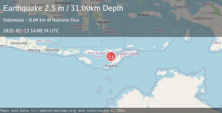
A 2.5 magnitude earthquake struck on Timor Region, at Fri, 13 Feb 2026 14:00:34 GMT. Depth: 31.398899km. Reviewed by BMKG seismologists, this minor quake occurred at a magnitude type of M.
Magnitude
2.5
M
Source
BMKG
Intensity
-
Agency Reports
1 Sources| Source | Magnitude | Depth | Time |
|---|---|---|---|
| BMKGPrimary | 2.5 | 31 km | 5 days ago |
Earthquake Details
ManualEvent IDbmg2026dbqj
Tsunami PotentialNo
Magnitude TypeM
Nearest Places
- Nuaf Panmolo26.6 km
- Kapuktulis33.8 km
- Nono Oelpasi34.0 km
- Nono Pakun34.3 km
- Nono Tliman34.6 km
Comments
Join the discussion about this event.
Latest Earthquakes
1.6Mag
41 km NW of Toyah, Texas
Time22 hours ago
Depth3.46 km
SourceUSGS (Automatic)
0.7Mag
6 km WNW of Cobb, CA
Time22 hours ago
Depth-0.59 km
SourceUSGS (Automatic)
1.0Mag
Southern Alaska
Time22 hours ago
Depth0.12 km
SourceVYT (Automatic)
2.1Mag
Sumbawa Region, Indonesia
Time22 hours ago
Depth21.86 km
SourceBMKG
4.0Mag
northwest of Australia
Time22 hours ago
Depth91.80 km
SourceVYT (Automatic)
Nearby Earthquakes
5.0Mag
TIMOR REGION, INDONESIA
Time3 years ago
Depth100.00 km
SourceEMSC (Automatic)
5.0Mag
TIMOR REGION, INDONESIA
Time6 years ago
Depth83.00 km
SourceEMSC (Automatic)
3.0Mag
TIMOR REGION, INDONESIA
Time3 years ago
Depth27.00 km
SourceDJA (Automatic)
3.0Mag
TIMOR REGION, INDONESIA
Time11 months ago
Depth48.00 km
SourceBMKG (Automatic)
2.6Mag
Timor Region
Time1 week ago
Depth16.69 km
SourceBMKG (Automatic)