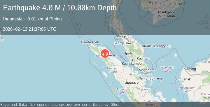
Earthquake Northern Sumatra, Indonesia
Fri, 13 Feb 2026 21:37:05 GMT
Time1 week ago
Location
4.2103, 97.5621
Depth
10.0 KM
Event Summary
A 4.0 magnitude earthquake struck on Northern Sumatra, Indonesia, at Fri, 13 Feb 2026 21:37:05 GMT. Depth: 10km. Reviewed by BMKG seismologists, this light quake occurred at a magnitude type of M.
Magnitude
4.0
M
Source
BMKG
Intensity
-
Agency Reports
2 Sources| Source | Magnitude | Depth | Time |
|---|---|---|---|
| BMKGPrimary | 4.0 | 10 km | 1 week ago |
| VYT | 4.1 | 0 km | 1 week ago |
Earthquake Details
ManualEvent IDbmg2026dcfk
Tsunami PotentialNo
Magnitude TypeM
Nearest Places
- 1.8 km
- 2.1 km
- 3.1 km
- 3.3 km
- 3.5 km
Comments
Join the discussion about this event.
Latest Earthquakes
2.5Mag
Antofagasta, Chile
Time2 minutes ago
Depth233.52 km
SourceVYT (Automatic)
1.8Mag
5 km SE of Santa Barbara, CA
Time4 minutes ago
Depth6.41 km
SourceUSGS (Automatic)
2.5Mag
OKLAHOMA
Time6 minutes ago
Depth3.10 km
SourceOK (Automatic)
3.3Mag
northern Sumatra, Indonesia
Time8 minutes ago
Depth0.00 km
SourceVYT (Automatic)
2.5Mag
Sulawesi, Indonesia
Time19 minutes ago
Depth0.00 km
SourceVYT (Automatic)
Nearby Earthquakes
2.8Mag
NORTHERN SUMATRA, INDONESIA
Time1 week ago
Depth5.00 km
SourceBMKG (Automatic)
2.7Mag
Northern Sumatra, Indonesia
Time1 week ago
Depth1.00 km
SourceBMKG
3.1Mag
northern Sumatra, Indonesia
Time1 hour ago
Depth0.00 km
SourceVYT (Automatic)
3.0Mag
NORTHERN SUMATRA, INDONESIA
Time4 months ago
Depth10.00 km
SourceBMKG (Automatic)
3.6Mag
NORTHERN SUMATRA, INDONESIA
Time1 month ago
Depth0.00 km
SourceBMKG (Automatic)