Earthquake Northern Molucca Sea
Sat, 14 Feb 2026 18:59:33 GMT
Time5 days ago
Location
1.8464, 125.8560
Depth
28.2 KM
Event Summary
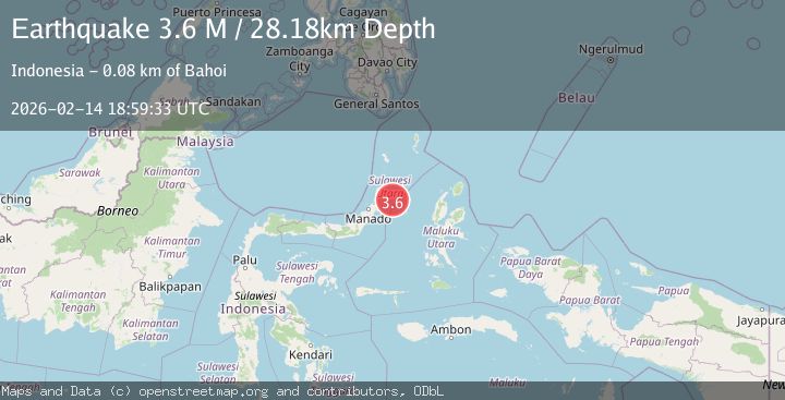
A 3.6 magnitude earthquake struck on Northern Molucca Sea, at Sat, 14 Feb 2026 18:59:33 GMT. Depth: 28.182756km. Reviewed by BMKG seismologists, this minor quake occurred at a magnitude type of M.
Magnitude
3.6
M
Source
BMKG
Intensity
-
Agency Reports
1 Sources| Source | Magnitude | Depth | Time |
|---|---|---|---|
| BMKGPrimary | 3.6 | 28 km | 5 days ago |
Earthquake Details
ManualEvent IDbmg2026ddvs
Tsunami PotentialNo
Magnitude TypeM
Nearest Places
- Pulau Batumeo57.3 km
- Tonggeng Kalioho57.5 km
- Tonggeng Bahu57.5 km
- Tonggeng Lensehe57.8 km
- Tonggeng Katiabu58.3 km
Comments
Join the discussion about this event.
Latest Earthquakes
2.4Mag
38 km WSW of Empire, Nevada
Time15 hours ago
Depth7.86 km
SourceUSGS (Automatic)
1.8Mag
23 km ENE of San Ardo, CA
Time15 hours ago
Depth-0.74 km
SourceUSGS (Automatic)
4.2Mag
NEAR EAST COAST OF HONSHU, JAPAN
Time15 hours ago
Depth30.00 km
SourceJMA (Automatic)
1.1Mag
Fox Islands, Aleutian Islands, Alaska
Time15 hours ago
Depth0.00 km
SourceVYT (Automatic)
3.2Mag
WESTERN TURKEY
Time15 hours ago
Depth6.20 km
SourceKOERI (Automatic)
Nearby Earthquakes
4.0Mag
MOLUCCA SEA
Time6 years ago
Depth28.00 km
SourceDJA (Automatic)
6.0Mag
MOLUCCA SEA
Time20 years ago
Depth33.00 km
SourceEMSC (Automatic)
3.4Mag
MOLUCCA SEA
Time1 month ago
Depth91.00 km
SourceBMKG (Automatic)
4.0Mag
MOLUCCA SEA
Time6 years ago
Depth12.00 km
SourceDJA (Automatic)
3.0Mag
MOLUCCA SEA
Time5 years ago
Depth12.00 km
SourceDJA (Automatic)