Earthquake Seram, Indonesia
Sat, 14 Feb 2026 23:47:14 GMT
Time4 days ago
Location
-3.1118, 129.6468
Depth
38.4 KM
Event Summary
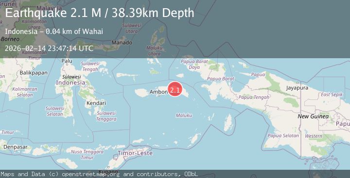
A 2.1 magnitude earthquake struck on Seram, Indonesia, at Sat, 14 Feb 2026 23:47:14 GMT. Depth: 38.388882km. Reviewed by BMKG seismologists, this minor quake occurred at a magnitude type of M.
Magnitude
2.1
M
Source
BMKG
Intensity
-
Agency Reports
1 Sources| Source | Magnitude | Depth | Time |
|---|---|---|---|
| BMKGPrimary | 2.1 | 38 km | 4 days ago |
Earthquake Details
ManualEvent IDbmg2026deff
Tsunami PotentialNo
Magnitude TypeM
Nearest Places
- Hatu Sapulewana2.9 km
- Inahel3.4 km
- Desa Maraina4.7 km
- Desa Kanikeh5.3 km
- Hatuolo5.4 km
Comments
Join the discussion about this event.
Latest Earthquakes
4.5Mag
North of Halmahera, Indonesia
Time7 minutes ago
Depth10.00 km
SourceBMKG
3.1Mag
Bali Region, Indonesia
Time13 minutes ago
Depth19.14 km
SourceBMKG
2.7Mag
Coquimbo, Chile
Time14 minutes ago
Depth14.16 km
SourceVYT (Automatic)
1.7Mag
Southeastern Alaska
Time16 minutes ago
Depth5.98 km
SourceVYT (Automatic)
2.1Mag
Tarapaca, Chile
Time17 minutes ago
Depth110.35 km
SourceVYT (Automatic)
Nearby Earthquakes
5.5Mag
SERAM, INDONESIA
Time14 years ago
Depth26.00 km
SourceEMSC (Automatic)
5.0Mag
SERAM, INDONESIA
Time19 years ago
Depth30.00 km
SourceEMSC (Automatic)
3.2Mag
SERAM, INDONESIA
Time1 month ago
Depth28.00 km
SourceBMKG (Automatic)
5.2Mag
SERAM, INDONESIA
Time19 years ago
Depth45.00 km
SourceEMSC (Automatic)
6.3Mag
SERAM, INDONESIA
Time19 years ago
Depth2.00 km
SourceEMSC (Automatic)