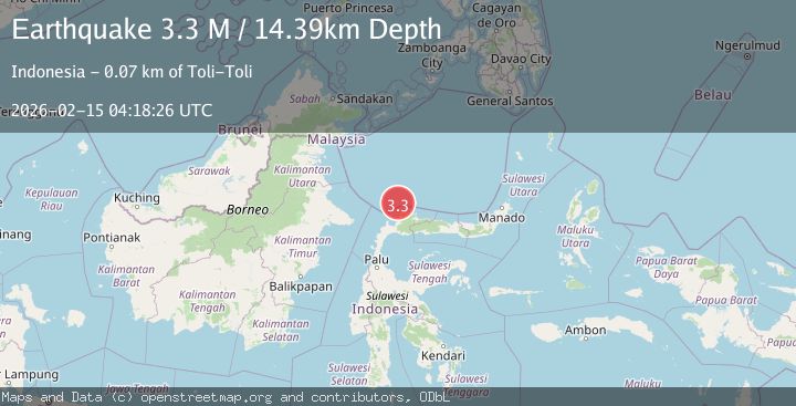
Earthquake Minahassa Peninsula, Sulawesi
Sun, 15 Feb 2026 04:18:26 GMT
Time4 days ago
Location
1.6863, 120.7432
Depth
14.4 KM
Event Summary
A 3.3 magnitude earthquake struck on Minahassa Peninsula, Sulawesi, at Sun, 15 Feb 2026 04:18:26 GMT. Depth: 14.39194km. Reviewed by BMKG seismologists, this minor quake occurred at a magnitude type of M.
Magnitude
3.3
M
Source
BMKG
Intensity
-
Agency Reports
1 Sources| Source | Magnitude | Depth | Time |
|---|---|---|---|
| BMKGPrimary | 3.3 | 14 km | 4 days ago |
Earthquake Details
ManualEvent IDbmg2026deoe
Tsunami PotentialNo
Magnitude TypeM
Nearest Places
- Pulau Dolangon38.9 km
- Kepulauan Silando39.3 km
- Pulau Silando39.4 km
- Tanjung Binar40.8 km
- Tanjung Santigi40.9 km
Comments
Join the discussion about this event.
Latest Earthquakes
1.5Mag
48 km WNW of Tatitlek, Alaska
Time15 hours ago
Depth5.00 km
SourceUSGS (Automatic)
2.7Mag
Unimak Island region, Alaska
Time15 hours ago
Depth0.00 km
SourceVYT (Automatic)
1.6Mag
Kenai Peninsula, Alaska
Time15 hours ago
Depth78.98 km
SourceVYT (Automatic)
2.3Mag
Region Metropolitana, Chile
Time15 hours ago
Depth19.17 km
SourceVYT (Automatic)
2.2Mag
Minahasa, Sulawesi, Indonesia
Time15 hours ago
Depth13.06 km
SourceVYT (Automatic)
Nearby Earthquakes
3.0Mag
MINAHASA, SULAWESI, INDONESIA
Time4 months ago
Depth41.00 km
SourceBMKG (Automatic)
3.0Mag
MINAHASA, SULAWESI, INDONESIA
Time3 weeks ago
Depth29.00 km
SourceBMKG (Automatic)
3.1Mag
MINAHASA, SULAWESI, INDONESIA
Time1 month ago
Depth27.00 km
SourceBMKG (Automatic)
4.0Mag
MINAHASA, SULAWESI, INDONESIA
Time6 months ago
Depth452.00 km
SourceBMKG (Automatic)
3.4Mag
MINAHASA, SULAWESI, INDONESIA
Time1 month ago
Depth5.00 km
SourceBMKG (Automatic)