Earthquake West Papua, Indonesia
Sun, 15 Feb 2026 19:53:53 GMT
Time3 days ago
Location
-2.9550, 137.0838
Depth
10.0 KM
Event Summary
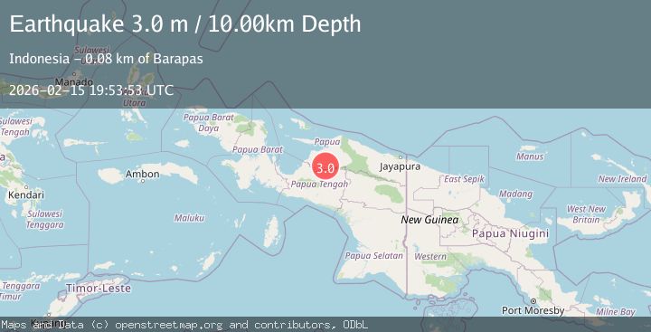
A 3.0 magnitude earthquake struck on West Papua, Indonesia, at Sun, 15 Feb 2026 19:53:53 GMT. Depth: 10km. Reviewed by BMKG seismologists, this minor quake occurred at a magnitude type of M.
Magnitude
3.0
M
Source
BMKG
Intensity
-
Agency Reports
1 Sources| Source | Magnitude | Depth | Time |
|---|---|---|---|
| BMKGPrimary | 3.0 | 10 km | 3 days ago |
Earthquake Details
ManualEvent IDbmg2026dfta
Tsunami PotentialNo
Magnitude TypeM
Nearest Places
- Kampung Aru Antu7.3 km
- Kampung Dairi17.2 km
- Kampung Foira17.3 km
- A River21.6 km
- Hill Top Bivouac22.9 km
Comments
Join the discussion about this event.
Latest Earthquakes
4.2Mag
Fox Islands, Aleutian Islands, Alaska
Time5 minutes ago
Depth0.00 km
SourceVYT (Automatic)
1.8Mag
Sweden
Time6 minutes ago
Depth0.00 km
SourceVYT (Automatic)
2.0Mag
Bali Region, Indonesia
Time6 minutes ago
Depth73.97 km
SourceBMKG
2.5Mag
Java, Indonesia
Time7 minutes ago
Depth38.78 km
SourceBMKG
2.4Mag
Poland
Time7 minutes ago
Depth2.81 km
SourceVYT (Automatic)
Nearby Earthquakes
2.5Mag
PAPUA, INDONESIA
Time2 weeks ago
Depth10.00 km
SourceBMKG (Automatic)
5.0Mag
NEAR N COAST OF PAPUA, INDONESIA
Time9 years ago
Depth30.00 km
SourceEMSC (Automatic)
4.0Mag
NEAR N COAST OF PAPUA, INDONESIA
Time1 year ago
Depth29.00 km
SourceBMKG (Automatic)
5.6Mag
PAPUA, INDONESIA
Time8 years ago
Depth20.00 km
SourceEMSC (Automatic)
5.0Mag
PAPUA, INDONESIA
Time2 years ago
Depth43.00 km
SourceEMSC (Automatic)