Earthquake South of Bali, Indonesia
Mon, 16 Feb 2026 07:49:28 GMT
Time5 days ago
Location
-9.2401, 114.7913
Depth
65.6 KM
Event Summary
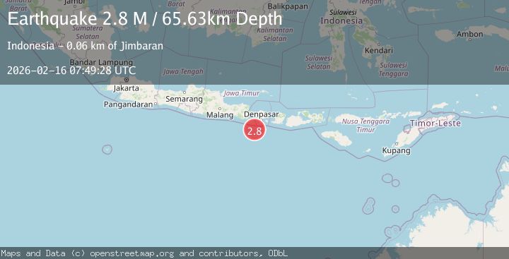
A 2.8 magnitude earthquake struck on South of Bali, Indonesia, at Mon, 16 Feb 2026 07:49:28 GMT. Depth: 65.631432km. Reviewed by BMKG seismologists, this minor quake occurred at a magnitude type of M.
Magnitude
2.8
M
Source
BMKG
Intensity
-
Agency Reports
1 Sources| Source | Magnitude | Depth | Time |
|---|---|---|---|
| BMKGPrimary | 2.8 | 66 km | 5 days ago |
Earthquake Details
ManualEvent IDbmg2026dgqq
Tsunami PotentialNo
Magnitude TypeM
Nearest Places
- 55.4 km
- 55.9 km
- 56.0 km
- 56.1 km
- 56.2 km
Comments
Join the discussion about this event.
Latest Earthquakes
1.0Mag
Alaska Peninsula
Time5 minutes ago
Depth0.00 km
SourceVYT (Automatic)
1.6Mag
Germany
Time8 minutes ago
Depth0.00 km
SourceVYT (Automatic)
1.7Mag
Southern Alaska
Time9 minutes ago
Depth0.00 km
SourceVYT (Automatic)
2.3Mag
Tarapaca, Chile
Time12 minutes ago
Depth101.32 km
SourceVYT (Automatic)
3.2Mag
Southern Alaska
Time14 minutes ago
Depth78.13 km
SourceVYT (Automatic)
Nearby Earthquakes
5.0Mag
SOUTH OF BALI, INDONESIA
Time7 years ago
Depth80.00 km
SourceEMSC (Automatic)
4.4Mag
SOUTH OF BALI, INDONESIA
Time1 month ago
Depth10.00 km
SourceBMKG (Automatic)
2.8Mag
SOUTH OF BALI, INDONESIA
Time1 month ago
Depth37.00 km
SourceBMKG (Automatic)
3.0Mag
SOUTH OF BALI, INDONESIA
Time4 years ago
Depth45.00 km
SourceDJA (Automatic)
2.7Mag
South of Bali, Indonesia
Time3 hours ago
Depth44.05 km
SourceBMKG