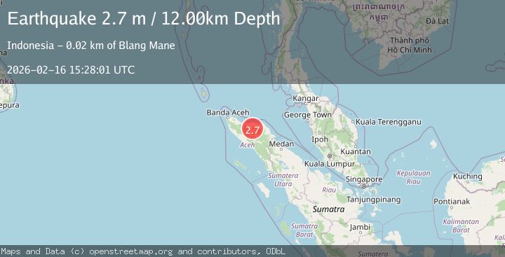
Earthquake Northern Sumatra, Indonesia
Mon, 16 Feb 2026 15:28:01 GMT
Time5 days ago
Location
4.9090, 96.8555
Depth
12.4 KM
Event Summary
A 2.7 magnitude earthquake struck on Northern Sumatra, Indonesia, at Mon, 16 Feb 2026 15:28:01 GMT. Depth: 12.412005km. Reviewed by BMKG seismologists, this minor quake occurred at a magnitude type of M.
Magnitude
2.7
M
Source
BMKG
Intensity
-
Agency Reports
1 Sources| Source | Magnitude | Depth | Time |
|---|---|---|---|
| BMKGPrimary | 2.7 | 12 km | 5 days ago |
Earthquake Details
ManualEvent IDbmg2026dhft
Tsunami PotentialNo
Magnitude TypeM
Nearest Places
- 1.5 km
- 2.7 km
- 2.7 km
- 3.5 km
- 4.0 km
Comments
Join the discussion about this event.
Latest Earthquakes
1.7Mag
Central Alaska
Time3 minutes ago
Depth166.50 km
SourceVYT (Automatic)
2.2Mag
Sweden
Time3 minutes ago
Depth0.00 km
SourceVYT (Automatic)
1.3Mag
Northern Territory, Australia
Time22 minutes ago
Depth0.00 km
SourceVYT (Automatic)
1.7Mag
Java, Indonesia
Time24 minutes ago
Depth12.57 km
SourceVYT (Automatic)
1.7Mag
Tarapaca, Chile
Time25 minutes ago
Depth107.91 km
SourceVYT (Automatic)
Nearby Earthquakes
4.1Mag
Northern Sumatra, Indonesia
Time2 weeks ago
Depth10.00 km
SourceBMKG (Automatic)
3.0Mag
NORTHERN SUMATRA, INDONESIA
Time5 months ago
Depth10.00 km
SourceBMKG (Automatic)
3.0Mag
NORTHERN SUMATRA, INDONESIA
Time5 months ago
Depth10.00 km
SourceBMKG (Automatic)
3.0Mag
NORTHERN SUMATRA, INDONESIA
Time5 months ago
Depth10.00 km
SourceBMKG (Automatic)
3.4Mag
NORTHERN SUMATRA, INDONESIA
Time1 month ago
Depth5.00 km
SourceBMKG (Automatic)