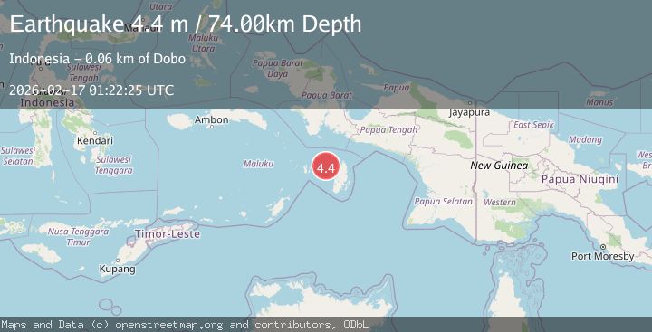
Earthquake Aru Islands Region, Indonesia
Tue, 17 Feb 2026 01:22:25 GMT
Time1 day ago
Location
-5.5859, 133.7568
Depth
74.1 KM
Event Summary
A 4.4 magnitude earthquake struck on Aru Islands Region, Indonesia, at Tue, 17 Feb 2026 01:22:25 GMT. Depth: 74.087364km. Reviewed by BMKG seismologists, this light quake occurred at a magnitude type of M.
Magnitude
4.4
M
Source
BMKG
Intensity
-
Agency Reports
1 Sources| Source | Magnitude | Depth | Time |
|---|---|---|---|
| BMKGPrimary | 4.4 | 74 km | 1 day ago |
Earthquake Details
ManualEvent IDbmg2026dhzj
Tsunami PotentialNo
Magnitude TypeM
Nearest Places
- Jurjela51.7 km
- Tanjung Ular51.9 km
- Kora52.1 km
- Wakaltoeltoelak52.5 km
- Tanjung Malakafani52.5 km
Comments
Join the discussion about this event.
Latest Earthquakes
2.0Mag
Central California
Time18 hours ago
Depth0.00 km
SourceVYT (Automatic)
0.7Mag
4 km NW of The Geysers, CA
Time18 hours ago
Depth3.05 km
SourceUSGS (Automatic)
2.7Mag
northern Colombia
Time18 hours ago
Depth73.00 km
SourceVYT (Automatic)
1.8Mag
2 km SW of Pāhala, Hawaii
Time18 hours ago
Depth29.79 km
SourceUSGS (Automatic)
1.0Mag
4 km W of Lake Henshaw, CA
Time18 hours ago
Depth12.06 km
SourceUSGS (Automatic)
Nearby Earthquakes
5.3Mag
KEPULAUAN KAI, INDONESIA
Time5 years ago
Depth10.00 km
SourceEMSC (Automatic)
5.1Mag
Kepulauan Aru region, Indonesia
Time1 day ago
Depth10.00 km
SourceVYT (Automatic)
5.4Mag
KEPULAUAN KAI, INDONESIA
Time18 years ago
Depth32.00 km
SourceEMSC (Automatic)
5.8Mag
KEPULAUAN KAI, INDONESIA
Time7 years ago
Depth10.00 km
SourceEMSC (Automatic)
5.0Mag
KEPULAUAN KAI, INDONESIA
Time18 years ago
Depth33.00 km
SourceEMSC (Automatic)