Earthquake Halmahera, Indonesia
Tue, 17 Feb 2026 14:09:52 GMT
Time17 hours ago
Location
1.3928, 128.2773
Depth
64.7 KM
Event Summary
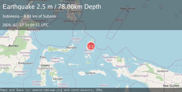
A 2.2 magnitude earthquake struck on Halmahera, Indonesia, at Tue, 17 Feb 2026 14:09:52 GMT. Depth: 64.702751km. Reviewed by BMKG seismologists, this minor quake occurred at a magnitude type of M.
Magnitude
2.2
M
Source
BMKG
Intensity
-
Agency Reports
1 Sources| Source | Magnitude | Depth | Time |
|---|---|---|---|
| BMKGPrimary | 2.2 | 65 km | 17 hours ago |
Earthquake Details
ManualEvent IDbmg2026diyr
Tsunami PotentialNo
Magnitude TypeM
Nearest Places
- Desa Iga2.2 km
- Ake Tutua4.4 km
- Tanjung Tutua4.5 km
- Iga4.9 km
- Ake Kolocina5.1 km
Comments
Join the discussion about this event.
Latest Earthquakes
2.5Mag
offshore Valparaiso, Chile
Time17 hours ago
Depth11.47 km
SourceVYT (Automatic)
1.7Mag
Central Alaska
Time17 hours ago
Depth0.00 km
SourceVYT (Automatic)
1.0Mag
6 km NNE of Four Mile Road, Alaska
Time18 hours ago
Depth2.00 km
SourceUSGS (Automatic)
2.4Mag
DODECANESE ISLANDS, GREECE
Time18 hours ago
Depth3.00 km
SourceTHE (Automatic)
2.8Mag
Flores region, Indonesia
Time18 hours ago
Depth14.40 km
SourceVYT (Automatic)
Nearby Earthquakes
2.8Mag
HALMAHERA, INDONESIA
Time1 month ago
Depth66.00 km
SourceBMKG (Automatic)
2.8Mag
Halmahera, Indonesia
Time3 days ago
Depth0.00 km
SourceVYT (Automatic)
5.0Mag
HALMAHERA, INDONESIA
Time2 years ago
Depth90.00 km
SourceEMSC (Automatic)
5.0Mag
HALMAHERA, INDONESIA
Time12 years ago
Depth109.00 km
SourceEMSC (Automatic)
3.0Mag
HALMAHERA, INDONESIA
Time4 years ago
Depth10.00 km
SourceDJA (Automatic)