Earthquake Bali Sea
Tue, 17 Feb 2026 18:05:39 GMT
Time15 hours ago
Location
-7.7993, 117.2036
Depth
18.1 KM
Event Summary
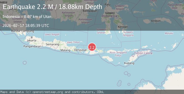
A 2.2 magnitude earthquake struck on Bali Sea, at Tue, 17 Feb 2026 18:05:39 GMT. Depth: 18.082712km. Reviewed by BMKG seismologists, this minor quake occurred at a magnitude type of M.
Magnitude
2.2
M
Source
BMKG
Intensity
-
Agency Reports
1 Sources| Source | Magnitude | Depth | Time |
|---|---|---|---|
| BMKGPrimary | 2.2 | 18 km | 15 hours ago |
Earthquake Details
ManualEvent IDbmg2026djgl
Tsunami PotentialNo
Magnitude TypeM
Nearest Places
- Pulau Sadapur2.6 km
- Gosong Sakunci5.8 km
- Gosong Sadapur9.6 km
- Karang Satengar23.9 km
- Desa Satanger31.5 km
Comments
Join the discussion about this event.
Latest Earthquakes
1.9Mag
Central Alaska
Time15 hours ago
Depth100.95 km
SourceVYT (Automatic)
5.4Mag
Java, Indonesia
Time15 hours ago
Depth178.10 km
SourceVYT (Automatic)
2.1Mag
Antofagasta, Chile
Time15 hours ago
Depth0.00 km
SourceVYT (Automatic)
3.1Mag
DODECANESE IS.-TURKEY BORDER REG
Time15 hours ago
Depth17.00 km
SourceTHE (Automatic)
3.1Mag
south of Alaska
Time15 hours ago
Depth10.00 km
SourceVYT (Automatic)
Nearby Earthquakes
2.3Mag
Bali Sea
Time1 week ago
Depth9.07 km
SourceBMKG (Automatic)
5.1Mag
BALI SEA
Time12 years ago
Depth300.00 km
SourceEMSC (Automatic)
2.5Mag
Bali Sea
Time3 days ago
Depth10.00 km
SourceBMKG
2.2Mag
Bali Sea
Time2 weeks ago
Depth10.00 km
SourceBMKG (Automatic)
2.2Mag
Bali Sea
Time2 weeks ago
Depth10.00 km
SourceBMKG (Automatic)