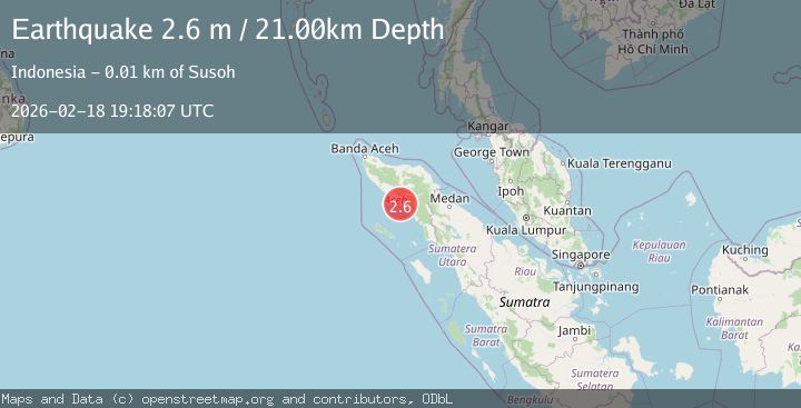
Earthquake Northern Sumatra, Indonesia
Wed, 18 Feb 2026 19:18:07 GMT
Time1 hour ago
Location
3.6875, 96.7411
Depth
20.8 KM
Event Summary
A 2.6 magnitude earthquake struck on Northern Sumatra, Indonesia, at Wed, 18 Feb 2026 19:18:07 GMT. Depth: 20.841639km. Reviewed by BMKG seismologists, this minor quake occurred at a magnitude type of M.
Magnitude
2.6
M
Source
BMKG
Intensity
-
Agency Reports
1 Sources| Source | Magnitude | Depth | Time |
|---|---|---|---|
| BMKGPrimary | 2.6 | 21 km | 1 hour ago |
Earthquake Details
ManualEvent IDbmg2026dlej
Tsunami PotentialNo
Magnitude TypeM
Nearest Places
- Kuala Batee6.2 km
- Krueng Batee7.1 km
- Teluk Susoh7.3 km
- Ujung Pulaukayu7.4 km
- Krueng Susoh7.4 km
Comments
Join the discussion about this event.
Latest Earthquakes
1.8Mag
Central Alaska
Time1 hour ago
Depth103.03 km
SourceVYT (Automatic)
1.3Mag
Washington
Time2 hours ago
Depth0.00 km
SourceVYT (Automatic)
1.6Mag
Kenai Peninsula, Alaska
Time2 hours ago
Depth21.36 km
SourceVYT (Automatic)
2.4Mag
Java, Indonesia
Time2 hours ago
Depth23.99 km
SourceBMKG
3.1Mag
Near North Coast of West Papua
Time2 hours ago
Depth46.31 km
SourceBMKG
Nearby Earthquakes
3.0Mag
NORTHERN SUMATRA, INDONESIA
Time2 years ago
Depth35.00 km
SourceBMKG (Automatic)
5.0Mag
NORTHERN SUMATRA, INDONESIA
Time21 years ago
Depth33.00 km
SourceEMSC (Automatic)
3.0Mag
NORTHERN SUMATRA, INDONESIA
Time1 year ago
Depth50.00 km
SourceBMKG (Automatic)
3.0Mag
NORTHERN SUMATRA, INDONESIA
Time6 months ago
Depth10.00 km
SourceBMKG (Automatic)
3.0Mag
NORTHERN SUMATRA, INDONESIA
Time2 months ago
Depth10.00 km
SourceBMKG (Automatic)