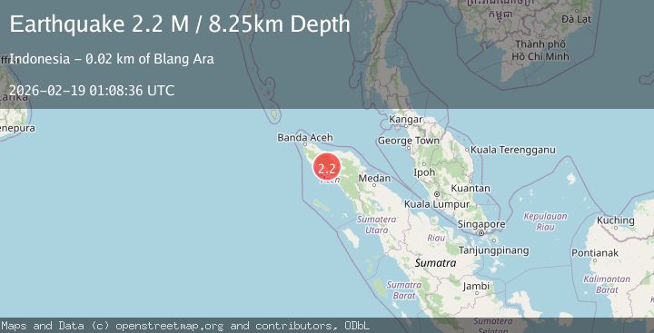
Earthquake Northern Sumatra, Indonesia
Thu, 19 Feb 2026 01:08:36 GMT
Time1 hour ago
Location
4.4991, 96.3742
Depth
8.3 KM
Event Summary
A 2.2 magnitude earthquake struck on Northern Sumatra, Indonesia, at Thu, 19 Feb 2026 01:08:36 GMT. Depth: 8.252036km. Reviewed by BMKG seismologists, this minor quake occurred at a magnitude type of M.
Magnitude
2.2
M
Source
BMKG
Intensity
-
Agency Reports
1 Sources| Source | Magnitude | Depth | Time |
|---|---|---|---|
| BMKGPrimary | 2.2 | 8 km | 1 hour ago |
Earthquake Details
ManualEvent IDbmg2026dlpx
Tsunami PotentialNo
Magnitude TypeM
Nearest Places
- Sikundo1.9 km
- Juemeurang2.3 km
- Tuwi Babak2.5 km
- Meunasah2.7 km
- Tuwi Meuglea2.9 km
Comments
Join the discussion about this event.
Latest Earthquakes
2.5Mag
Tarapaca, Chile
Time1 hour ago
Depth112.55 km
SourceVYT (Automatic)
2.0Mag
ALBANIA
Time1 hour ago
Depth15.00 km
SourceIGEO (Automatic)
2.3Mag
CENTRAL TURKEY
Time1 hour ago
Depth6.20 km
SourceAFAD (Automatic)
2.2Mag
Tarapaca, Chile
Time1 hour ago
Depth111.94 km
SourceVYT (Automatic)
1.9Mag
Central Alaska
Time1 hour ago
Depth32.10 km
SourceVYT (Automatic)
Nearby Earthquakes
2.5Mag
Northern Sumatra, Indonesia
Time2 weeks ago
Depth7.53 km
SourceBMKG (Automatic)
2.3Mag
Northern Sumatra, Indonesia
Time1 day ago
Depth5.22 km
SourceBMKG
3.0Mag
NORTHERN SUMATRA, INDONESIA
Time3 years ago
Depth10.00 km
SourceDJA (Automatic)
3.0Mag
NORTHERN SUMATRA, INDONESIA
Time2 years ago
Depth10.00 km
SourceBMKG (Automatic)
4.0Mag
NORTHERN SUMATRA, INDONESIA
Time1 year ago
Depth10.00 km
SourceBMKG (Automatic)