Earthquake Minahassa Peninsula, Sulawesi
Thu, 19 Feb 2026 09:40:41 GMT
Time1 hour ago
Location
1.5644, 122.1386
Depth
20.6 KM
Event Summary
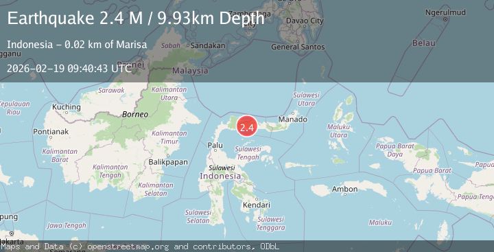
A 2.1 magnitude earthquake struck on Minahassa Peninsula, Sulawesi, at Thu, 19 Feb 2026 09:40:41 GMT. Depth: 20.619093km. Reviewed by BMKG seismologists, this minor quake occurred at a magnitude type of M.
Magnitude
2.1
M
Source
BMKG
Intensity
-
Agency Reports
1 Sources| Source | Magnitude | Depth | Time |
|---|---|---|---|
| BMKGPrimary | 2.1 | 21 km | 1 hour ago |
Earthquake Details
ManualEvent IDbmg2026dmgu
Tsunami PotentialNo
Magnitude TypeM
Nearest Places
- Karang Ponilungan52.6 km
- Karang Lobu53.1 km
- Karang Bulilanga53.3 km
- Karang Bulolio54.2 km
- Batu Lumajagu55.1 km
Comments
Join the discussion about this event.
Latest Earthquakes
0.7Mag
Southern Alaska
Time1 hour ago
Depth0.00 km
SourceVYT (Automatic)
0.9Mag
13 km E of Coso Junction, CA
Time1 hour ago
Depth1.49 km
SourceUSGS (Automatic)
1.6Mag
Southern Alaska
Time1 hour ago
Depth25.15 km
SourceVYT (Automatic)
1.7Mag
Czech Republic
Time1 hour ago
Depth0.00 km
SourceVYT (Automatic)
2.4Mag
Central Alaska
Time1 hour ago
Depth1.71 km
SourceVYT (Automatic)
Nearby Earthquakes
3.0Mag
MINAHASA, SULAWESI, INDONESIA
Time10 months ago
Depth10.00 km
SourceBMKG (Automatic)
2.8Mag
Minahassa Peninsula, Sulawesi
Time7 hours ago
Depth11.18 km
SourceBMKG
5.7Mag
Minahasa, Sulawesi, Indonesia
Time10 hours ago
Depth31.98 km
SourceVYT (Automatic)
5.1Mag
MINAHASA, SULAWESI, INDONESIA
Time16 years ago
Depth38.00 km
SourceEMSC (Automatic)
7.4Mag
MINAHASA, SULAWESI, INDONESIA
Time17 years ago
Depth20.00 km
SourceEMSC (Automatic)