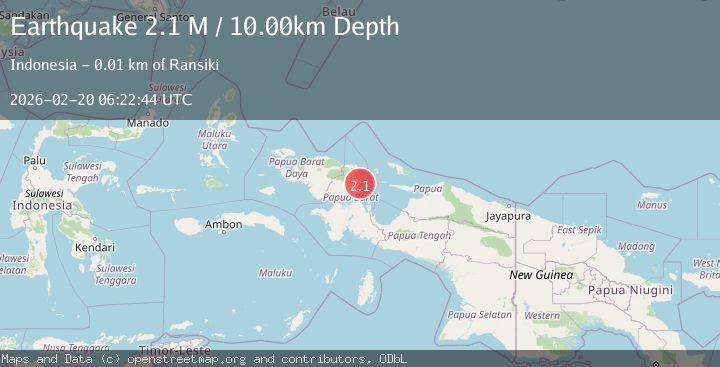
Earthquake West Papua Region, Indonesia
Fri, 20 Feb 2026 06:22:44 GMT
Time1 hour ago
Location
-1.5794, 134.1929
Depth
10.0 KM
Event Summary
A 2.1 magnitude earthquake struck on West Papua Region, Indonesia, at Fri, 20 Feb 2026 06:22:44 GMT. Depth: 10km. Reviewed by BMKG seismologists, this minor quake occurred at a magnitude type of M.
Magnitude
2.1
M
Source
BMKG
Intensity
-
Agency Reports
1 Sources| Source | Magnitude | Depth | Time |
|---|---|---|---|
| BMKGPrimary | 2.1 | 10 km | 1 hour ago |
Earthquake Details
ManualEvent IDbmg2026dnvu
Tsunami PotentialNo
Magnitude TypeM
Nearest Places
- Waria2.3 km
- Tanjung Yori3.9 km
- Kampung Hamawi4.9 km
- Mami5.6 km
- Momi5.7 km
Comments
Join the discussion about this event.
Latest Earthquakes
2.6Mag
Poland
Time1 hour ago
Depth3.78 km
SourceVYT (Automatic)
1.4Mag
western Texas
Time1 hour ago
Depth0.12 km
SourceVYT (Automatic)
2.9Mag
ISLAND OF HAWAII, HAWAII
Time1 hour ago
Depth6.10 km
SourceHV (Automatic)
2.5Mag
Java, Indonesia
Time1 hour ago
Depth29.01 km
SourceBMKG
2.8Mag
ISLAND OF HAWAII, HAWAII
Time1 hour ago
Depth6.70 km
SourceHV (Automatic)
Nearby Earthquakes
5.2Mag
NEAR N COAST OF PAPUA, INDONESIA
Time3 years ago
Depth29.00 km
SourceEMSC (Automatic)
6.6Mag
NEAR N COAST OF PAPUA, INDONESIA
Time13 years ago
Depth10.00 km
SourceEMSC (Automatic)
4.0Mag
NEAR N COAST OF PAPUA, INDONESIA
Time5 years ago
Depth10.00 km
SourceDJA (Automatic)
4.0Mag
near the north coast of Papua, Indonesia
Time1 week ago
Depth0.00 km
SourceVYT (Automatic)
3.0Mag
NEAR N COAST OF PAPUA, INDONESIA
Time3 months ago
Depth22.00 km
SourceBMKG (Automatic)