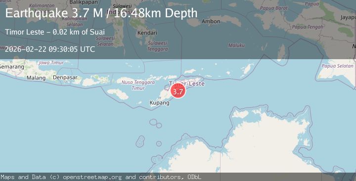
Earthquake Timor Region
Sun, 22 Feb 2026 09:30:03 GMT
Time1 hour ago
Location
-9.4749, 125.3604
Depth
13.1 KM
Event Summary
A 3.0 magnitude earthquake struck on Timor Region, at Sun, 22 Feb 2026 09:30:03 GMT. Depth: 13.094705km. Reviewed by BMKG seismologists, this minor quake occurred at a magnitude type of M.
Magnitude
3.0
M
Source
BMKG
Intensity
-
Agency Reports
1 Sources| Source | Magnitude | Depth | Time |
|---|---|---|---|
| BMKGPrimary | 3.0 | 13 km | 1 hour ago |
Earthquake Details
ManualEvent IDbmg2026drsz
Tsunami PotentialNo
Magnitude TypeM
Nearest Places
- 16.4 km
- 16.7 km
- 16.7 km
- 16.7 km
- 16.7 km
Comments
Join the discussion about this event.
Latest Earthquakes
3.0Mag
Gulf of Alaska
Time1 hour ago
Depth140.50 km
SourceVYT (Automatic)
2.9Mag
Sumba region, Indonesia
Time1 hour ago
Depth55.18 km
SourceVYT (Automatic)
1.5Mag
Fox Islands, Aleutian Islands, Alaska
Time1 hour ago
Depth40.77 km
SourceVYT (Automatic)
1.3Mag
13 km SW of Searles Valley, CA
Time1 hour ago
Depth4.25 km
SourceUSGS (Automatic)
2.7Mag
Near North Coast of West Papua
Time1 hour ago
Depth17.60 km
SourceBMKG
Nearby Earthquakes
5.6Mag
EAST TIMOR REGION
Time9 years ago
Depth20.00 km
SourceEMSC (Automatic)
3.1Mag
Timor Region
Time0 months ago
Depth10.00 km
SourceBMKG (Automatic)
3.0Mag
EAST TIMOR REGION
Time5 years ago
Depth10.00 km
SourceDJA (Automatic)
3.0Mag
EAST TIMOR REGION
Time2 years ago
Depth23.00 km
SourceBMKG (Automatic)
2.8Mag
EAST TIMOR REGION
Time1 month ago
Depth10.00 km
SourceBMKG (Automatic)