Earthquake West Papua, Indonesia
Mon, 23 Feb 2026 18:33:30 GMT
Time3 hours ago
Location
-3.9728, 138.5119
Depth
10.0 KM
Event Summary
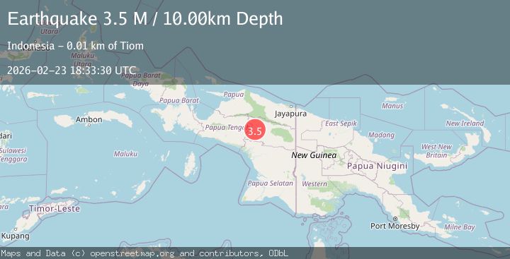
A 3.5 magnitude earthquake struck on West Papua, Indonesia, at Mon, 23 Feb 2026 18:33:30 GMT. Depth: 10km. Reviewed by BMKG seismologists, this minor quake occurred at a magnitude type of M.
Magnitude
3.5
M
Source
BMKG
Intensity
-
Agency Reports
1 Sources| Source | Magnitude | Depth | Time |
|---|---|---|---|
| BMKGPrimary | 3.5 | 10 km | 3 hours ago |
Earthquake Details
ManualEvent IDbmg2026dugk
Tsunami PotentialNo
Magnitude TypeM
Nearest Places
- 0.8 km
- 1.0 km
- 1.3 km
- 1.4 km
- 1.6 km
Comments
Join the discussion about this event.
Latest Earthquakes
1.1Mag
5 km NW of The Geysers, CA
Time3 hours ago
Depth2.17 km
SourceUSGS (Automatic)
3.7Mag
northern Sumatra, Indonesia
Time4 hours ago
Depth0.00 km
SourceVYT (Automatic)
2.5Mag
Southern Alaska
Time4 hours ago
Depth8.18 km
SourceVYT (Automatic)
1.7Mag
15 km SE of Pleasanton, Texas
Time4 hours ago
Depth14.54 km
SourceUSGS (Automatic)
1.3Mag
5 km WNW of The Geysers, CA
Time4 hours ago
Depth3.31 km
SourceUSGS (Automatic)
Nearby Earthquakes
4.2Mag
West Papua, Indonesia
Time2 days ago
Depth117.65 km
SourceBMKG
4.0Mag
Papua, Indonesia
Time1 week ago
Depth100.83 km
SourceVYT (Automatic)
5.0Mag
PAPUA, INDONESIA
Time2 years ago
Depth101.00 km
SourceEMSC (Automatic)
5.0Mag
PAPUA, INDONESIA
Time11 years ago
Depth30.00 km
SourceEMSC (Automatic)
5.0Mag
PAPUA, INDONESIA
Time1 month ago
Depth140.00 km
SourceEMSC (Automatic)