Earthquake Timor Region
Mon, 23 Feb 2026 22:11:36 GMT
Time23 hours ago
Location
-9.8071, 124.9851
Depth
10.0 KM
Event Summary
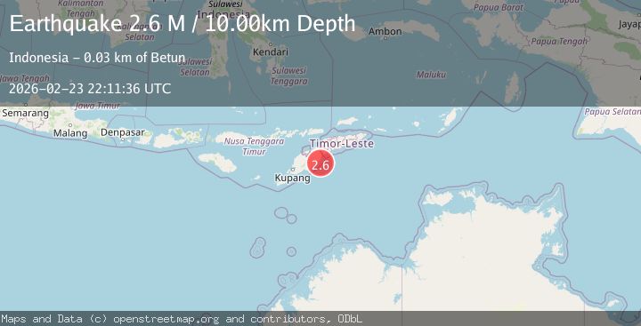
A 2.6 magnitude earthquake struck on Timor Region, at Mon, 23 Feb 2026 22:11:36 GMT. Depth: 10km. Reviewed by BMKG seismologists, this minor quake occurred at a magnitude type of M.
Magnitude
2.6
M
Source
BMKG
Intensity
-
Agency Reports
1 Sources| Source | Magnitude | Depth | Time |
|---|---|---|---|
| BMKGPrimary | 2.6 | 10 km | 23 hours ago |
Earthquake Details
ManualEvent IDbmg2026dunp
Tsunami PotentialNo
Magnitude TypeM
Nearest Places
- 4.3 km
- 14.9 km
- 15.5 km
- 15.9 km
- 15.9 km
Comments
Join the discussion about this event.
Latest Earthquakes
1.4Mag
Tarapaca, Chile
Time23 hours ago
Depth100.95 km
SourceVYT (Automatic)
0.8Mag
2 km NW of The Geysers, CA
Time23 hours ago
Depth1.24 km
SourceUSGS (Automatic)
1.2Mag
63 km WNW of Karluk, Alaska
Time23 hours ago
Depth17.20 km
SourceUSGS (Automatic)
3.1Mag
Fox Islands, Aleutian Islands, Alaska
Time23 hours ago
Depth0.00 km
SourceVYT (Automatic)
2.3Mag
San Juan, Argentina
Time23 hours ago
Depth137.08 km
SourceVYT (Automatic)
Nearby Earthquakes
2.9Mag
TIMOR REGION
Time1 month ago
Depth9.00 km
SourceBMKG (Automatic)
2.9Mag
Timor Region
Time2 weeks ago
Depth28.13 km
SourceBMKG (Automatic)
5.3Mag
EAST TIMOR REGION
Time1 year ago
Depth10.00 km
SourceEMSC (Automatic)
4.0Mag
EAST TIMOR REGION
Time1 year ago
Depth11.00 km
SourceBMKG (Automatic)
3.0Mag
EAST TIMOR REGION
Time1 year ago
Depth10.00 km
SourceBMKG (Automatic)