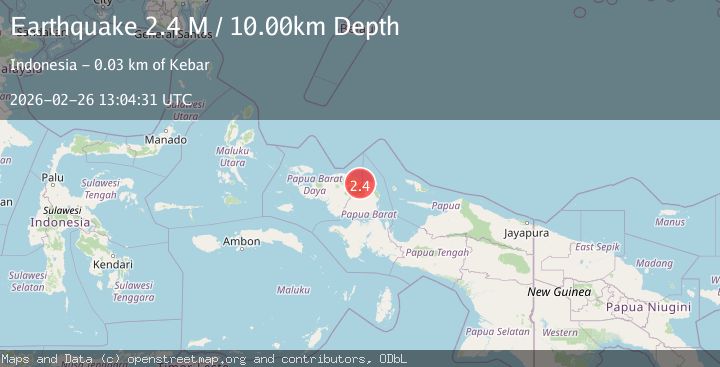
Earthquake West Papua Region, Indonesia
Thu, 26 Feb 2026 13:04:33 GMT
Time1 hour ago
Location
-0.8023, 133.4518
Depth
10.7 KM
Event Summary
A 2.2 magnitude earthquake struck on West Papua Region, Indonesia, at Thu, 26 Feb 2026 13:04:33 GMT. Depth: 10.682994km. Reviewed by BMKG seismologists, this minor quake occurred at a magnitude type of M.
Magnitude
2.2
M
Source
BMKG
Intensity
-
Agency Reports
1 Sources| Source | Magnitude | Depth | Time |
|---|---|---|---|
| BMKGPrimary | 2.2 | 11 km | 1 hour ago |
Earthquake Details
ManualEvent IDbmg2026dzic
Tsunami PotentialNo
Magnitude TypeM
Nearest Places
- 1.9 km
- 2.4 km
- 2.7 km
- 4.2 km
- 4.3 km
Comments
Join the discussion about this event.
Latest Earthquakes
2.2Mag
Java, Indonesia
Time1 hour ago
Depth123.90 km
SourceBMKG
2.6Mag
ISLAND OF HAWAII, HAWAII
Time1 hour ago
Depth41.10 km
SourceHV (Automatic)
2.2Mag
Near North Coast of West Papua
Time1 hour ago
Depth10.00 km
SourceBMKG
4.1Mag
New Guinea, Papua New Guinea
Time1 hour ago
Depth233.89 km
SourceVYT (Automatic)
1.8Mag
34 km NNW of Toyah, Texas
Time1 hour ago
Depth7.16 km
SourceUSGS (Automatic)
Nearby Earthquakes
2.5Mag
West Papua Region, Indonesia
Time2 weeks ago
Depth16.79 km
SourceBMKG (Automatic)
5.0Mag
NEAR N COAST OF PAPUA, INDONESIA
Time7 years ago
Depth20.00 km
SourceEMSC (Automatic)
5.6Mag
NEAR N COAST OF PAPUA, INDONESIA
Time16 years ago
Depth22.00 km
SourceEMSC (Automatic)
2.7Mag
NEAR N COAST OF PAPUA, INDONESIA
Time1 month ago
Depth10.00 km
SourceBMKG (Automatic)
6.0Mag
NEAR N COAST OF PAPUA, INDONESIA
Time17 years ago
Depth30.00 km
SourceEMSC (Automatic)