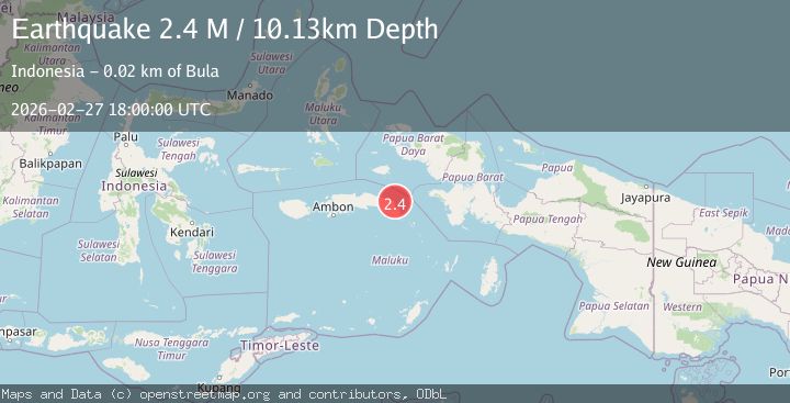
Earthquake Seram, Indonesia
Fri, 27 Feb 2026 18:00:01 GMT
Time4 hours ago
Location
-3.0237, 130.6404
Depth
10.1 KM
Event Summary
A 2.1 magnitude earthquake struck on Seram, Indonesia, at Fri, 27 Feb 2026 18:00:01 GMT. Depth: 10.087306km. Reviewed by BMKG seismologists, this minor quake occurred at a magnitude type of M.
Magnitude
2.1
M
Source
BMKG
Intensity
-
Agency Reports
1 Sources| Source | Magnitude | Depth | Time |
|---|---|---|---|
| BMKGPrimary | 2.1 | 10 km | 4 hours ago |
Earthquake Details
ManualEvent IDbmg2026ebnh
Tsunami PotentialNo
Magnitude TypeM
Nearest Places
- 13.4 km
- 14.4 km
- 15.1 km
- 15.4 km
- 15.8 km
Comments
Join the discussion about this event.
Latest Earthquakes
3.3Mag
Antofagasta, Chile
Time4 hours ago
Depth0.00 km
SourceVYT (Automatic)
2.0Mag
northern Sumatra, Indonesia
Time4 hours ago
Depth0.00 km
SourceVYT (Automatic)
3.8Mag
Fox Islands, Aleutian Islands, Alaska
Time4 hours ago
Depth24.41 km
SourceVYT (Automatic)
1.8Mag
53 km ESE of Naalehu, Hawaii
Time4 hours ago
Depth18.79 km
SourceUSGS (Automatic)
1.9Mag
southern Quebec, Canada
Time4 hours ago
Depth3.91 km
SourceVYT (Automatic)
Nearby Earthquakes
4.0Mag
SERAM, INDONESIA
Time1 year ago
Depth10.00 km
SourceBMKG (Automatic)
3.0Mag
SERAM, INDONESIA
Time2 years ago
Depth10.00 km
SourceBMKG (Automatic)
3.0Mag
SERAM, INDONESIA
Time3 years ago
Depth10.00 km
SourceDJA (Automatic)
2.1Mag
Seram, Indonesia
Time2 weeks ago
Depth10.00 km
SourceBMKG
3.0Mag
SERAM, INDONESIA
Time5 years ago
Depth10.00 km
SourceDJA (Automatic)