Earthquake Near North Coast of West Papua
Sat, 28 Feb 2026 11:49:35 GMT
Time1 hour ago
Location
-1.7978, 138.9145
Depth
9.1 KM
Event Summary
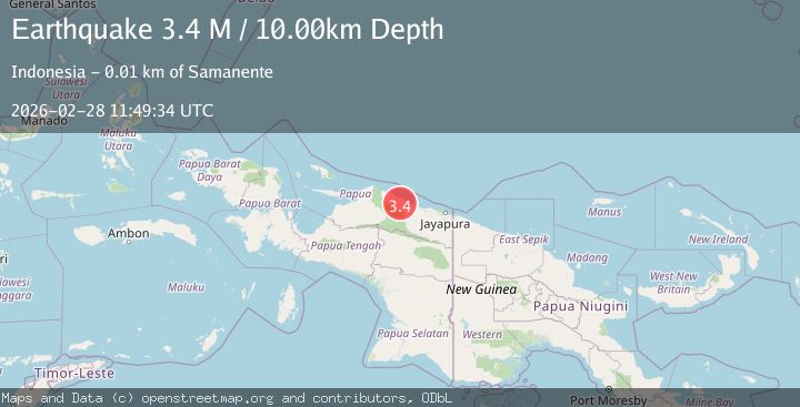
A 3.2 magnitude earthquake struck on Near North Coast of West Papua, at Sat, 28 Feb 2026 11:49:35 GMT. Depth: 9.120884km. Reviewed by BMKG seismologists, this minor quake occurred at a magnitude type of M.
Magnitude
3.2
M
Source
BMKG
Intensity
-
Agency Reports
1 Sources| Source | Magnitude | Depth | Time |
|---|---|---|---|
| BMKGPrimary | 3.2 | 9 km | 1 hour ago |
Earthquake Details
ManualEvent IDbmg2026ecwp
Tsunami PotentialNo
Magnitude TypeM
Nearest Places
- 17.9 km
- 18.2 km
- 18.4 km
- 18.4 km
- 18.4 km
Comments
Join the discussion about this event.
Latest Earthquakes
1.5Mag
Southern Alaska
Time1 hour ago
Depth0.00 km
SourceVYT (Automatic)
3.3Mag
San Juan, Argentina
Time1 hour ago
Depth109.01 km
SourceVYT (Automatic)
2.1Mag
Tarapaca, Chile
Time1 hour ago
Depth11.96 km
SourceVYT (Automatic)
1.6Mag
89 km NE of Tonopah, Nevada
Time1 hour ago
Depth6.40 km
SourceUSGS (Automatic)
2.3Mag
Sumba Region, Indonesia
Time1 hour ago
Depth51.18 km
SourceBMKG
Nearby Earthquakes
2.9Mag
Near North Coast of West Papua
Time1 week ago
Depth20.59 km
SourceBMKG
2.8Mag
NEAR N COAST OF PAPUA, INDONESIA
Time1 month ago
Depth10.00 km
SourceBMKG (Automatic)
2.8Mag
Near North Coast of West Papua
Time3 days ago
Depth10.00 km
SourceBMKG
4.0Mag
NEAR N COAST OF PAPUA, INDONESIA
Time1 year ago
Depth21.00 km
SourceBMKG (Automatic)
4.0Mag
NEAR N COAST OF PAPUA, INDONESIA
Time5 months ago
Depth10.00 km
SourceBMKG (Automatic)