Earthquake Minahassa Peninsula, Sulawesi
Sat, 28 Feb 2026 14:50:55 GMT
Time1 hour ago
Location
1.3032, 120.7865
Depth
5.9 KM
Event Summary
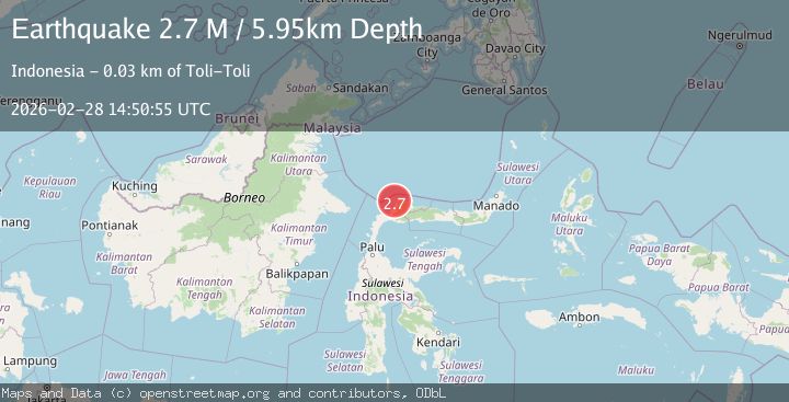
A 2.7 magnitude earthquake struck on Minahassa Peninsula, Sulawesi, at Sat, 28 Feb 2026 14:50:55 GMT. Depth: 5.947711km. Reviewed by BMKG seismologists, this minor quake occurred at a magnitude type of M.
Magnitude
2.7
M
Source
BMKG
Intensity
-
Agency Reports
1 Sources| Source | Magnitude | Depth | Time |
|---|---|---|---|
| BMKGPrimary | 2.7 | 6 km | 1 hour ago |
Earthquake Details
ManualEvent IDbmg2026edco
Tsunami PotentialNo
Magnitude TypeM
Nearest Places
- 1.5 km
- 1.6 km
- 3.0 km
- 3.1 km
- 3.4 km
Comments
Join the discussion about this event.
Latest Earthquakes
1.7Mag
47 km NW of Toyah, Texas
Time1 hour ago
Depth4.01 km
SourceUSGS (Automatic)
3.3Mag
near the north coast of Papua, Indonesia
Time1 hour ago
Depth20.39 km
SourceVYT (Automatic)
1.3Mag
Central Alaska
Time1 hour ago
Depth3.54 km
SourceVYT (Automatic)
3.3Mag
West Papua, Indonesia
Time1 hour ago
Depth10.23 km
SourceBMKG
0.8Mag
8 km NW of The Geysers, CA
Time1 hour ago
Depth1.90 km
SourceUSGS (Automatic)
Nearby Earthquakes
3.0Mag
MINAHASA, SULAWESI, INDONESIA
Time3 months ago
Depth17.00 km
SourceBMKG (Automatic)
4.0Mag
MINAHASA, SULAWESI, INDONESIA
Time1 year ago
Depth20.00 km
SourceBMKG (Automatic)
2.1Mag
Minahassa Peninsula, Sulawesi
Time7 hours ago
Depth3.79 km
SourceBMKG
5.8Mag
Minahasa, Sulawesi, Indonesia
Time9 hours ago
Depth0.00 km
SourceVYT (Automatic)
5.8Mag
MINAHASA, SULAWESI, INDONESIA
Time16 years ago
Depth24.00 km
SourceEMSC (Automatic)