Earthquake West Papua Region, Indonesia
Tue, 03 Mar 2026 05:03:43 GMT
Time7 hours ago
Location
-2.0938, 136.8870
Depth
389.3 KM
Event Summary
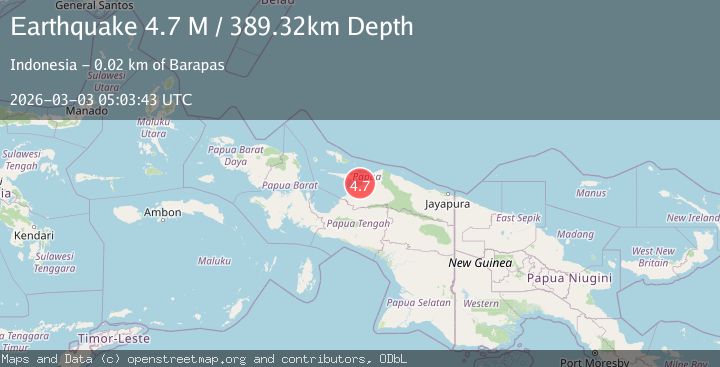
A 4.7 magnitude earthquake struck on West Papua Region, Indonesia, at Tue, 03 Mar 2026 05:03:43 GMT. Depth: 389.324127km. Reviewed by BMKG seismologists, this light quake occurred at a magnitude type of M.
Magnitude
4.7
M
Source
BMKG
Intensity
-
Agency Reports
1 Sources| Source | Magnitude | Depth | Time |
|---|---|---|---|
| BMKGPrimary | 4.7 | 389 km | 7 hours ago |
Earthquake Details
ManualEvent IDbmg2026ehvs
Tsunami PotentialNo
Magnitude TypeM
Nearest Places
- 12.5 km
- 12.7 km
- 12.8 km
- 13.7 km
- 15.3 km
Comments
Join the discussion about this event.
Latest Earthquakes
3.4Mag
northern Colombia
Time7 hours ago
Depth11.84 km
SourceVYT (Automatic)
1.9Mag
near the coast of Tarapaca, Chile
Time7 hours ago
Depth0.00 km
SourceVYT (Automatic)
3.4Mag
Fox Islands, Aleutian Islands, Alaska
Time7 hours ago
Depth21.36 km
SourceVYT (Automatic)
0.7Mag
4 km S of Mentone, CA
Time7 hours ago
Depth6.12 km
SourceUSGS (Automatic)
6.5Mag
off the west coast of northern Sumatra
Time7 hours ago
Depth10.00 km
SourceVYT (Automatic)
Nearby Earthquakes
3.0Mag
NEAR N COAST OF PAPUA, INDONESIA
Time3 weeks ago
Depth12.00 km
SourceBMKG (Automatic)
5.0Mag
NEAR N COAST OF PAPUA, INDONESIA
Time15 years ago
Depth10.00 km
SourceEMSC (Automatic)
4.0Mag
NEAR N COAST OF PAPUA, INDONESIA
Time1 year ago
Depth20.00 km
SourceBMKG (Automatic)
5.0Mag
NEAR N COAST OF PAPUA, INDONESIA
Time14 years ago
Depth40.00 km
SourceEMSC (Automatic)
6.4Mag
NEAR N COAST OF PAPUA, INDONESIA
Time14 years ago
Depth40.00 km
SourceEMSC (Automatic)