Earthquake Northern Molucca Sea
Tue, 03 Mar 2026 21:49:39 GMT
Time2 hours ago
Location
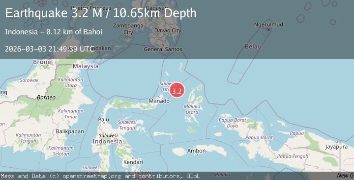
2.0845, 126.4538
Depth
10.7 KM
Event Summary
A 3.2 magnitude earthquake struck on Northern Molucca Sea, at Tue, 03 Mar 2026 21:49:39 GMT. Depth: 10.653195km. Reviewed by BMKG seismologists, this minor quake occurred at a magnitude type of M.
Magnitude
3.2
M
Source
BMKG
Intensity
-
Agency Reports
1 Sources| Source | Magnitude | Depth | Time |
|---|---|---|---|
| BMKGPrimary | 3.2 | 11 km | 2 hours ago |
Earthquake Details
ManualEvent IDbmg2026ejcx
Tsunami PotentialNo
Magnitude TypeM
Nearest Places
- 83.8 km
- 84.2 km
- 84.7 km
- 84.8 km
- 84.9 km
Comments
Join the discussion about this event.
Latest Earthquakes
1.8Mag
Kenai Peninsula, Alaska
Time1 hour ago
Depth12.21 km
SourceVYT (Automatic)
1.7Mag
Southern California
Time1 hour ago
Depth14.89 km
SourceVYT (Automatic)
3.7Mag
Tarapaca, Chile
Time2 hours ago
Depth57.01 km
SourceVYT (Automatic)
4.7Mag
Rat Islands, Aleutian Islands, Alaska
Time2 hours ago
Depth10.00 km
SourceVYT (Automatic)
2.8Mag
Greece-Albania border region
Time2 hours ago
Depth14.16 km
SourceVYT (Automatic)
Nearby Earthquakes
4.0Mag
MOLUCCA SEA
Time6 years ago
Depth46.00 km
SourceDJA (Automatic)
5.2Mag
MOLUCCA SEA
Time10 years ago
Depth31.00 km
SourceEMSC (Automatic)
5.1Mag
MOLUCCA SEA
Time11 years ago
Depth60.00 km
SourceEMSC (Automatic)
5.1Mag
MOLUCCA SEA
Time11 years ago
Depth51.00 km
SourceEMSC (Automatic)
5.0Mag
MOLUCCA SEA
Time2 months ago
Depth72.50 km
SourceEMSC (Automatic)