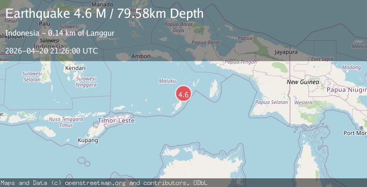
Earthquake Tanimbar Islands Region, Indonesia
Mon, 20 Apr 2026 21:26:00 GMT
Time1 week ago
Location
-6.5459, 131.8487
Depth
79.6 KM
Event Summary
A 4.6 magnitude earthquake struck on Tanimbar Islands Region, Indonesia, at Mon, 20 Apr 2026 21:26:00 GMT. Depth: 79.581543km. Reviewed by BMKG seismologists, this light quake occurred at a magnitude type of M.
Magnitude
4.6
M
Source
BMKG
Intensity
I
Agency Reports
4 Sources| Source | Magnitude | Depth | Time |
|---|---|---|---|
| BMKGPrimary | 4.6 | 80 km | 1 week ago |
| NEIC | 4.5 | 10 km | 1 week ago |
| USGS | 4.5 | 10 km | 1 week ago |
| EMSC | 4.5 | 34 km | 1 week ago |
Earthquake Details
ManualEvent IDbmg2026hsug
QualityS
Tsunami PotentialNo
Magnitude TypeM
Last Update1 week ago
Used Stations14
Felt Reports0
Did you feel this earthquake? Report it to help others.
No reports yet
Be the first to report this earthquake!
Latest Earthquakes
Loading...
Nearby Earthquakes
3.4Mag
Tanimbar Islands Region, Indonesia
Time7 hours ago
Depth116.88 km
SourceBMKG
3.6Mag
Tanimbar Islands Region, Indonesia
Time1 week ago
Depth96.01 km
SourceBMKG
5.2Mag
Tanimbar Islands Region, Indonesia
Time2 weeks ago
Depth99.09 km
SourceBMKG
3.9Mag
KEP. TANIMBAR REGION, INDONESIA
Time2 weeks ago
Depth74.00 km
SourceBMKG (Automatic)
3.7Mag
Tanimbar Islands Region, Indonesia
Time3 weeks ago
Depth96.81 km
SourceBMKG