Earthquake New Ireland Region, Papua New Guinea
Tue, 28 Apr 2026 10:27:26 GMT
Time4 days ago
Location
-4.7381, 153.5604
Depth
101.9 KM
Event Summary
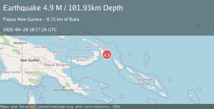
A 4.9 magnitude earthquake struck on New Ireland Region, Papua New Guinea, at Tue, 28 Apr 2026 10:27:26 GMT. Depth: 101.925461km. Reviewed by BMKG seismologists, this light quake occurred at a magnitude type of M.
Magnitude
4.9
M
Source
BMKG
Intensity
II
Agency Reports
3 Sources| Source | Magnitude | Depth | Time |
|---|---|---|---|
| BMKGPrimary | 4.9 | 102 km | 4 days ago |
| NEIC | 4.8 | 113 km | 4 days ago |
| EMSC | 4.8 | 105 km | 4 days ago |
Earthquake Details
ManualEvent IDbmg2026igoo
QualityS
Tsunami PotentialNo
Magnitude TypeM
Last Update4 days ago
Felt Reports0
Did you feel this earthquake? Report it to help others.
No reports yet
Be the first to report this earthquake!
Latest Earthquakes
Loading...
Nearby Earthquakes
4.8Mag
New Britain region, Papua New Guinea
Time7 hours ago
Depth48.46 km
SourceVYT (Automatic)
4.8Mag
NEW IRELAND REGION, P.N.G.
Time1 day ago
Depth10.00 km
SourceNEIC (Automatic)
4.2Mag
New Ireland Region, Papua New Guinea
Time4 days ago
Depth104.56 km
SourceBMKG
5.0Mag
NEW IRELAND REGION, P.N.G.
Time1 week ago
Depth105.00 km
SourceEMSC (Automatic)
4.8Mag
NEW IRELAND REGION, P.N.G.
Time1 week ago
Depth119.80 km
SourceNEIC (Automatic)