Earthquake PHILIPPINE ISLANDS REGION
Fri, 02 Jan 2026 14:32:38 GMT
Time6 hours ago
Location
5.8900, 127.2600
Depth
82.0 KM
Event Summary
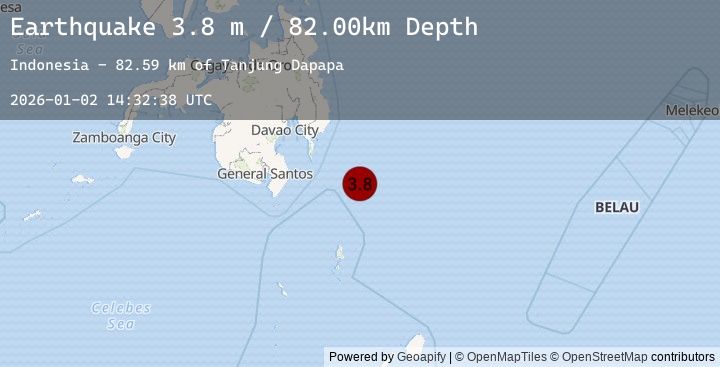
A 3.8 magnitude earthquake struck on PHILIPPINE ISLANDS REGION, at Fri, 02 Jan 2026 14:32:38 GMT. Depth: 82km. Reviewed by PIVS seismologists, this minor quake occurred at a magnitude type of m.
Magnitude
3.8
m
Source
PIVS
Intensity
-
Agency Reports
1 Sources| Source | Magnitude | Depth | Time |
|---|---|---|---|
| PIVSPrimary | 3.8 | 82 km | 6 hours ago |
Earthquake Details
AutomaticEvent IDemsc_20260102_0000189
Tsunami PotentialNo
Magnitude Typem
Nearest Places
- Tanjung Dapapa82.5 km
- Desa Pulau Miangas83.4 km
- Kecamatan Miangas83.5 km
- Pulau Miangas83.5 km
- Miangas84.2 km
Comments
Join the discussion about this event.
Latest Earthquakes
2.2Mag
54 km S of Manley Hot Springs, Alaska
Time6 hours ago
Depth3.70 km
SourceUSGS (Automatic)
2.4Mag
Java, Indonesia
Time6 hours ago
Depth82.46 km
SourceBMKG (Automatic)
2.7Mag
MONTENEGRO
Time6 hours ago
Depth15.00 km
SourceIGEO (Automatic)
2.9Mag
Sulawesi, Indonesia
Time6 hours ago
Depth2.88 km
SourceBMKG (Automatic)
2.1Mag
Minahassa Peninsula, Sulawesi
Time6 hours ago
Depth74.36 km
SourceBMKG (Automatic)